You are here: Home > Network List > TA - USArray Transportable Network (new EarthScope stations) Stations List
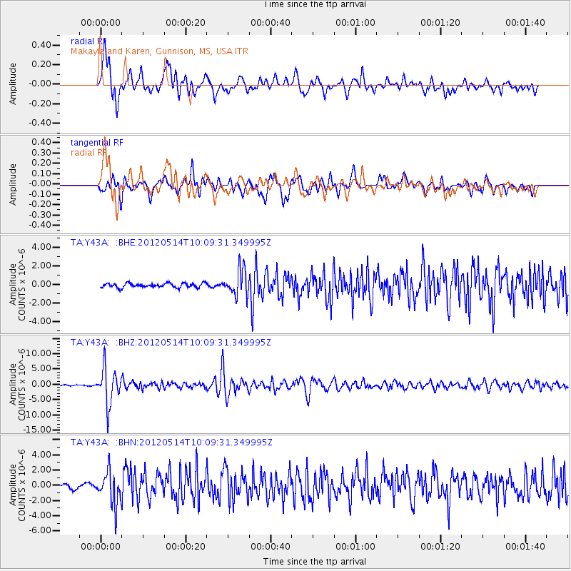
> Station Y43A Makayla and Karen, Gunnison, MS, USA > Earthquake Result Viewer
Y43A Makayla and Karen, Gunnison, MS, USA - Earthquake Result Viewer
| Earthquake location: |
Peru-Bolivia Border Region |
| Earthquake latitude/longitude: |
-17.7/-69.6 |
| Earthquake time(UTC): |
2012/05/14 (135) 10:00:40 GMT |
| Earthquake Depth: |
106 km |
| Earthquake Magnitude: |
6.4 MB, 6.2 MW, 6.2 MW |
| Earthquake Catalog/Contributor: |
WHDF/NEIC |
|
| Network: |
TA USArray Transportable Network (new EarthScope stations) |
| Station: |
Y43A Makayla and Karen, Gunnison, MS, USA |
| Lat/Lon: |
33.91 N/90.93 W |
| Elevation: |
46 m |
|
| Distance: |
55.2 deg |
| Az: |
338.374 deg |
| Baz: |
155.007 deg |
| Ray Param: |
0.06463144 |
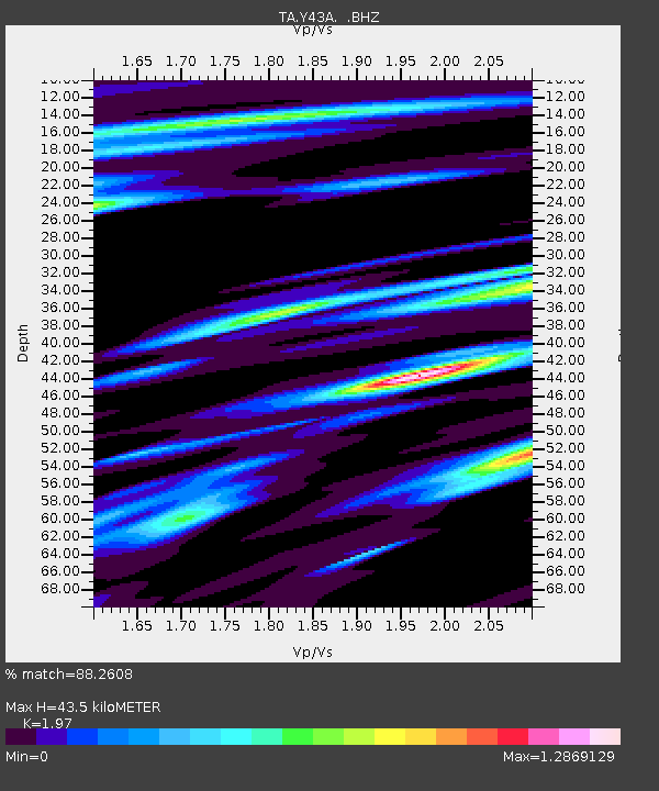
| Estimated Moho Depth: |
43.5 km |
| Estimated Crust Vp/Vs: |
1.97 |
| Assumed Crust Vp: |
6.201 km/s |
| Estimated Crust Vs: |
3.148 km/s |
| Estimated Crust Poisson's Ratio: |
0.33 |
|
| Radial Match: |
88.2608 % |
| Radial Bump: |
400 |
| Transverse Match: |
82.530815 % |
| Transverse Bump: |
400 |
| SOD ConfigId: |
446234 |
| Insert Time: |
2012-08-08 22:28:40.562 +0000 |
| GWidth: |
2.5 |
| Max Bumps: |
400 |
| Tol: |
0.001 |
|
Signal To Noise
| Channel | StoN | STA | LTA |
| TA:Y43A: :BHZ:20120514T10:09:31.349995Z | 41.991245 | 6.063869E-6 | 1.4440793E-7 |
| TA:Y43A: :BHN:20120514T10:09:31.349995Z | 8.489867 | 2.2355132E-6 | 2.6331546E-7 |
| TA:Y43A: :BHE:20120514T10:09:31.349995Z | 6.2233534 | 1.4198034E-6 | 2.2814122E-7 |
| Arrivals |
| Ps | 7.1 SECOND |
| PpPs | 20 SECOND |
| PsPs/PpSs | 27 SECOND |


