You are here: Home > Network List > TA - USArray Transportable Network (new EarthScope stations) Stations List
> Station Z46A Louisville, MS, USA > Earthquake Result Viewer
Z46A Louisville, MS, USA - Earthquake Result Viewer
| Earthquake location: |
Peru-Bolivia Border Region |
| Earthquake latitude/longitude: |
-17.7/-69.6 |
| Earthquake time(UTC): |
2012/05/14 (135) 10:00:40 GMT |
| Earthquake Depth: |
106 km |
| Earthquake Magnitude: |
6.4 MB, 6.2 MW, 6.2 MW |
| Earthquake Catalog/Contributor: |
WHDF/NEIC |
|
| Network: |
TA USArray Transportable Network (new EarthScope stations) |
| Station: |
Z46A Louisville, MS, USA |
| Lat/Lon: |
33.19 N/88.94 W |
| Elevation: |
125 m |
|
| Distance: |
53.9 deg |
| Az: |
339.877 deg |
| Baz: |
156.973 deg |
| Ray Param: |
0.06549334 |
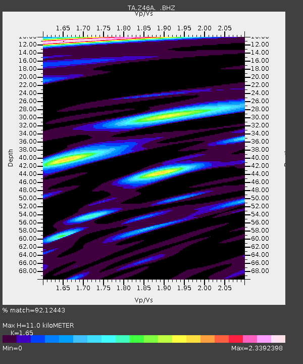
| Estimated Moho Depth: |
11.0 km |
| Estimated Crust Vp/Vs: |
1.65 |
| Assumed Crust Vp: |
6.201 km/s |
| Estimated Crust Vs: |
3.758 km/s |
| Estimated Crust Poisson's Ratio: |
0.21 |
|
| Radial Match: |
92.12443 % |
| Radial Bump: |
400 |
| Transverse Match: |
82.89114 % |
| Transverse Bump: |
400 |
| SOD ConfigId: |
446234 |
| Insert Time: |
2012-08-08 22:29:20.735 +0000 |
| GWidth: |
2.5 |
| Max Bumps: |
400 |
| Tol: |
0.001 |
|
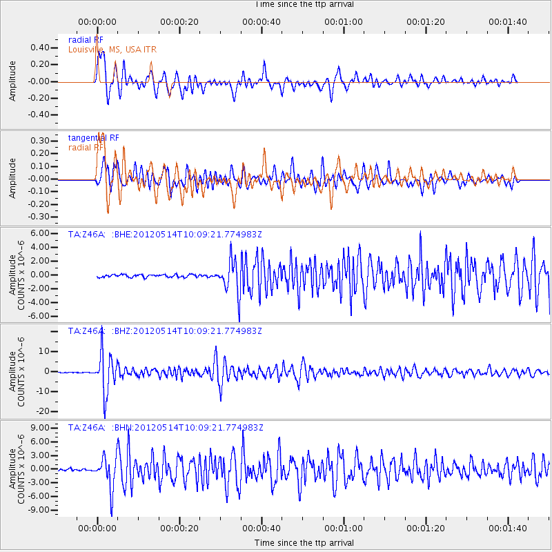
Signal To Noise
| Channel | StoN | STA | LTA |
| TA:Z46A: :BHZ:20120514T10:09:21.774983Z | 86.24026 | 9.947316E-6 | 1.15344235E-7 |
| TA:Z46A: :BHN:20120514T10:09:21.774983Z | 18.946184 | 3.5964076E-6 | 1.8982227E-7 |
| TA:Z46A: :BHE:20120514T10:09:21.774983Z | 13.017623 | 2.4073886E-6 | 1.8493304E-7 |
| Arrivals |
| Ps | 1.2 SECOND |
| PpPs | 4.5 SECOND |
| PsPs/PpSs | 5.7 SECOND |


