You are here: Home > Network List > G - GEOSCOPE Stations List
> Station NOUC Port Laguerre, New Caledonia > Earthquake Result Viewer
NOUC Port Laguerre, New Caledonia - Earthquake Result Viewer

| Earthquake location: |
Irian Jaya, Indonesia |
| Earthquake latitude/longitude: |
-2.6/138.2 |
| Earthquake time(UTC): |
1999/05/16 (136) 15:25:53 GMT |
| Earthquake Depth: |
59 km |
| Earthquake Magnitude: |
6.1 MB, 6.2 MS, 6.4 MW, 6.4 ME |
| Earthquake Catalog/Contributor: |
WHDF/NEIC |
|
| Network: |
G GEOSCOPE |
| Station: |
NOUC Port Laguerre, New Caledonia |
| Lat/Lon: |
22.10 S/166.30 E |
| Elevation: |
112 m |
|
| Distance: |
33.4 deg |
| Az: |
127.598 deg |
| Baz: |
301.413 deg |
| Ray Param: |
0.078065924 |
| Estimated Moho Depth: |
50.25 km |
| Estimated Crust Vp/Vs: |
1.99 |
| Assumed Crust Vp: |
5.14 km/s |
| Estimated Crust Vs: |
2.586 km/s |
| Estimated Crust Poisson's Ratio: |
0.33 |
|
| Radial Match: |
81.92095 % |
| Radial Bump: |
400 |
| Transverse Match: |
71.53973 % |
| Transverse Bump: |
400 |
| SOD ConfigId: |
4480 |
| Insert Time: |
2010-02-26 23:35:29.082 +0000 |
| GWidth: |
2.5 |
| Max Bumps: |
400 |
| Tol: |
0.001 |
|
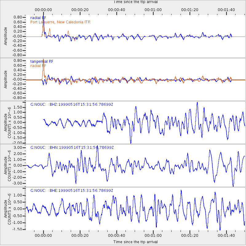
Signal To Noise
| Channel | StoN | STA | LTA |
| G:NOUC: :BHN:19990516T15:31:56.78699Z | 3.2514052 | 8.7648357E-7 | 2.6957068E-7 |
| G:NOUC: :BHE:19990516T15:31:56.78699Z | 1.3408759 | 2.49057E-7 | 1.8574202E-7 |
| G:NOUC: :BHZ:19990516T15:31:56.78699Z | 2.0249722 | 4.3958588E-7 | 2.1708242E-7 |
| Arrivals |
| Ps | 10 SECOND |
| PpPs | 28 SECOND |
| PsPs/PpSs | 38 SECOND |


