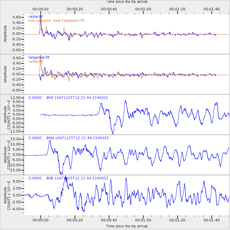
NOUC Port Laguerre, New Caledonia - Earthquake Result Viewer
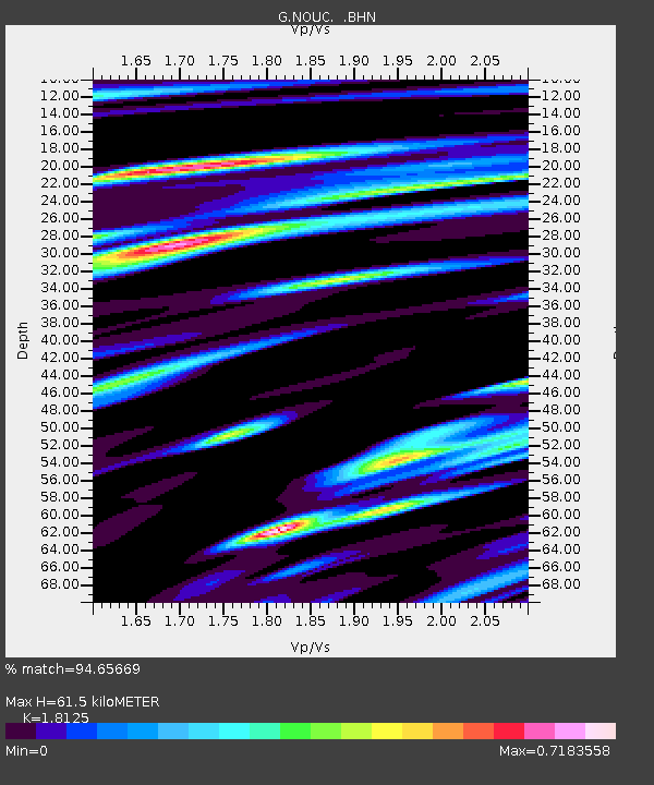
Earthquake location: Minahassa Peninsula, Sulawesi
Earthquake latitude/longitude: 1.2/122.5
Earthquake time(UTC): 1997/11/25 (329) 12:14:33 GMT
Earthquake Depth: 24 km
Earthquake Magnitude: 6.1 MB, 6.8 MS, 7.1 UNKNOWN, 6.7 ME
Earthquake Catalog/Contributor: WHDF/NEIC
Network: G GEOSCOPE
Station: NOUC Port Laguerre, New Caledonia
Lat/Lon: 22.10 S/166.30 E
Elevation: 112 m
Distance: 48.6 deg
Az: 121.193 deg
Baz: 292.752 deg
Ray Param: 0.06922618
Estimated Moho Depth: 61.5 km
Estimated Crust Vp/Vs: 1.81
Assumed Crust Vp: 5.14 km/s
Estimated Crust Vs: 2.836 km/s
Estimated Crust Poisson's Ratio: 0.28
Radial Match: 94.65669 %
Radial Bump: 400
Transverse Match: 89.05832 %
Transverse Bump: 400
SOD ConfigId: 4480
Insert Time: 2010-02-26 23:35:30.852 +0000
GWidth: 2.5
Max Bumps: 400
Tol: 0.001

Signal To Noise

ChannelStoNSTALTA
G:NOUC: :BHN:19971125T12:22:44.234003Z12.697732.8240884E-62.2240893E-7
G:NOUC: :BHE:19971125T12:22:44.234003Z1.1829752.3647742E-71.999006E-7
G:NOUC: :BHZ:19971125T12:22:44.234003Z9.3678591.6458465E-61.756908E-7
Arrivals
Ps10 SECOND
PpPs32 SECOND
PsPs/PpSs43 SECOND