You are here: Home > Network List > TA - USArray Transportable Network (new EarthScope stations) Stations List
> Station X43A Marvell, AR, USA > Earthquake Result Viewer
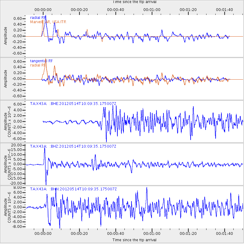
X43A Marvell, AR, USA - Earthquake Result Viewer
*The percent match for this event was below the threshold and hence no stack was calculated.
| Earthquake location: |
Peru-Bolivia Border Region |
| Earthquake latitude/longitude: |
-17.7/-69.6 |
| Earthquake time(UTC): |
2012/05/14 (135) 10:00:40 GMT |
| Earthquake Depth: |
106 km |
| Earthquake Magnitude: |
6.4 MB, 6.2 MW, 6.2 MW |
| Earthquake Catalog/Contributor: |
WHDF/NEIC |
|
| Network: |
TA USArray Transportable Network (new EarthScope stations) |
| Station: |
X43A Marvell, AR, USA |
| Lat/Lon: |
34.52 N/90.88 W |
| Elevation: |
53 m |
|
| Distance: |
55.7 deg |
| Az: |
338.725 deg |
| Baz: |
155.233 deg |
| Ray Param: |
$rayparam |
*The percent match for this event was below the threshold and hence was not used in the summary stack. |
|
| Radial Match: |
88.17013 % |
| Radial Bump: |
400 |
| Transverse Match: |
83.6938 % |
| Transverse Bump: |
400 |
| SOD ConfigId: |
446234 |
| Insert Time: |
2012-08-08 22:30:54.164 +0000 |
| GWidth: |
2.5 |
| Max Bumps: |
400 |
| Tol: |
0.001 |
|
Signal To Noise
| Channel | StoN | STA | LTA |
| TA:X43A: :BHZ:20120514T10:09:35.175007Z | 50.32751 | 8.357124E-6 | 1.6605479E-7 |
| TA:X43A: :BHN:20120514T10:09:35.175007Z | 10.882554 | 3.661125E-6 | 3.3642146E-7 |
| TA:X43A: :BHE:20120514T10:09:35.175007Z | 7.0108027 | 2.414047E-6 | 3.4433245E-7 |
| Arrivals |
| Ps | |
| PpPs | |
| PsPs/PpSs | |


