You are here: Home > Network List > TA - USArray Transportable Network (new EarthScope stations) Stations List
> Station S43A Fulton Ridge, Patton, MO, USA > Earthquake Result Viewer
S43A Fulton Ridge, Patton, MO, USA - Earthquake Result Viewer
| Earthquake location: |
Peru-Bolivia Border Region |
| Earthquake latitude/longitude: |
-17.7/-69.6 |
| Earthquake time(UTC): |
2012/05/14 (135) 10:00:40 GMT |
| Earthquake Depth: |
106 km |
| Earthquake Magnitude: |
6.4 MB, 6.2 MW, 6.2 MW |
| Earthquake Catalog/Contributor: |
WHDF/NEIC |
|
| Network: |
TA USArray Transportable Network (new EarthScope stations) |
| Station: |
S43A Fulton Ridge, Patton, MO, USA |
| Lat/Lon: |
37.57 N/90.08 W |
| Elevation: |
263 m |
|
| Distance: |
58.2 deg |
| Az: |
340.912 deg |
| Baz: |
156.897 deg |
| Ray Param: |
0.0626615 |
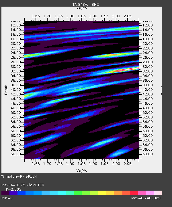
| Estimated Moho Depth: |
30.75 km |
| Estimated Crust Vp/Vs: |
2.07 |
| Assumed Crust Vp: |
6.53 km/s |
| Estimated Crust Vs: |
3.162 km/s |
| Estimated Crust Poisson's Ratio: |
0.35 |
|
| Radial Match: |
97.99124 % |
| Radial Bump: |
400 |
| Transverse Match: |
87.90601 % |
| Transverse Bump: |
400 |
| SOD ConfigId: |
446234 |
| Insert Time: |
2012-08-08 22:30:55.845 +0000 |
| GWidth: |
2.5 |
| Max Bumps: |
400 |
| Tol: |
0.001 |
|
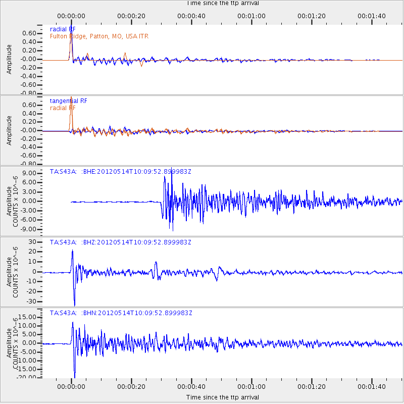
Signal To Noise
| Channel | StoN | STA | LTA |
| TA:S43A: :BHZ:20120514T10:09:52.899983Z | 204.85507 | 1.0838502E-5 | 5.2908145E-8 |
| TA:S43A: :BHN:20120514T10:09:52.899983Z | 105.28122 | 6.9825096E-6 | 6.632246E-8 |
| TA:S43A: :BHE:20120514T10:09:52.899983Z | 83.24495 | 4.025768E-6 | 4.8360505E-8 |
| Arrivals |
| Ps | 5.2 SECOND |
| PpPs | 14 SECOND |
| PsPs/PpSs | 19 SECOND |


