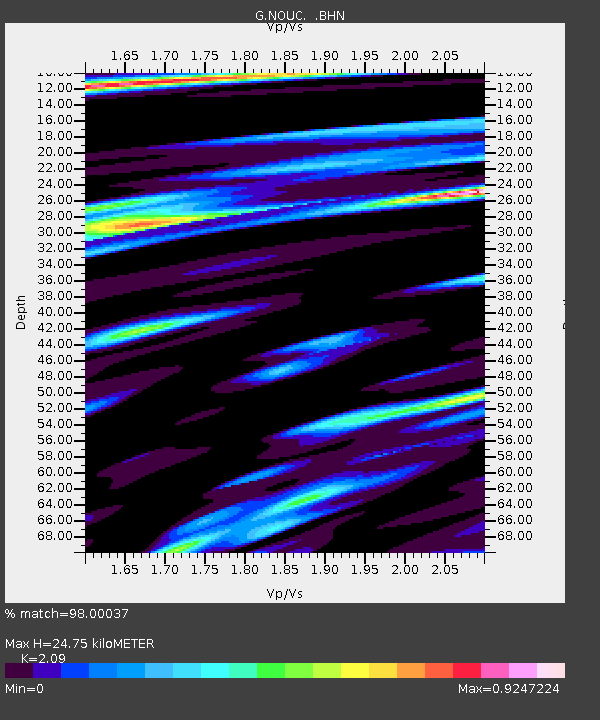
NOUC Port Laguerre, New Caledonia - Earthquake Result Viewer
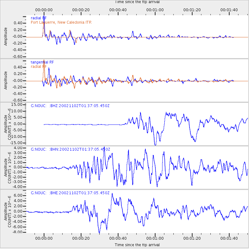
Earthquake location: Northern Sumatra, Indonesia
Earthquake latitude/longitude: 2.8/96.1
Earthquake time(UTC): 2002/11/02 (306) 01:26:10 GMT
Earthquake Depth: 30 km
Earthquake Magnitude: 6.2 MB, 7.6 MS, 7.4 MW, 7.4 MW
Earthquake Catalog/Contributor: WHDF/NEIC
Network: G GEOSCOPE
Station: NOUC Port Laguerre, New Caledonia
Lat/Lon: 22.10 S/166.30 E
Elevation: 112 m
Distance: 72.8 deg
Az: 114.025 deg
Baz: 280.361 deg
Ray Param: 0.05336108
Estimated Moho Depth: 24.75 km
Estimated Crust Vp/Vs: 2.09
Assumed Crust Vp: 5.14 km/s
Estimated Crust Vs: 2.459 km/s
Estimated Crust Poisson's Ratio: 0.35
Radial Match: 98.00037 %
Radial Bump: 400
Transverse Match: 94.25033 %
Transverse Bump: 400
SOD ConfigId: 4714
Insert Time: 2010-02-26 23:35:33.549 +0000
GWidth: 2.5
Max Bumps: 400
Tol: 0.001

Signal To Noise

ChannelStoNSTALTA
G:NOUC: :BHN:20021102T01:37:05.450Z1.1399981.1009022E-79.657054E-8
G:NOUC: :BHE:20021102T01:37:05.450Z1.05776231.5392315E-71.4551772E-7
G:NOUC: :BHZ:20021102T01:37:05.450Z1.62960472.1777386E-71.33636E-7
Arrivals
Ps5.3 SECOND
PpPs15 SECOND
PsPs/PpSs20 SECOND