You are here: Home > Network List > TA - USArray Transportable Network (new EarthScope stations) Stations List
> Station Q43A New Douglas, IL, USA > Earthquake Result Viewer
Q43A New Douglas, IL, USA - Earthquake Result Viewer
| Earthquake location: |
Peru-Bolivia Border Region |
| Earthquake latitude/longitude: |
-17.7/-69.6 |
| Earthquake time(UTC): |
2012/05/14 (135) 10:00:40 GMT |
| Earthquake Depth: |
106 km |
| Earthquake Magnitude: |
6.4 MB, 6.2 MW, 6.2 MW |
| Earthquake Catalog/Contributor: |
WHDF/NEIC |
|
| Network: |
TA USArray Transportable Network (new EarthScope stations) |
| Station: |
Q43A New Douglas, IL, USA |
| Lat/Lon: |
38.94 N/89.70 W |
| Elevation: |
202 m |
|
| Distance: |
59.4 deg |
| Az: |
341.849 deg |
| Baz: |
157.614 deg |
| Ray Param: |
0.0619131 |
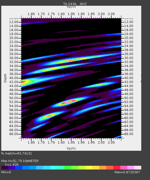
| Estimated Moho Depth: |
51.75 km |
| Estimated Crust Vp/Vs: |
1.84 |
| Assumed Crust Vp: |
6.444 km/s |
| Estimated Crust Vs: |
3.512 km/s |
| Estimated Crust Poisson's Ratio: |
0.29 |
|
| Radial Match: |
93.74101 % |
| Radial Bump: |
400 |
| Transverse Match: |
87.6763 % |
| Transverse Bump: |
400 |
| SOD ConfigId: |
446234 |
| Insert Time: |
2012-08-08 22:31:18.312 +0000 |
| GWidth: |
2.5 |
| Max Bumps: |
400 |
| Tol: |
0.001 |
|

Signal To Noise
| Channel | StoN | STA | LTA |
| TA:Q43A: :BHZ:20120514T10:10:00.800007Z | 72.46757 | 6.218568E-6 | 8.5811735E-8 |
| TA:Q43A: :BHN:20120514T10:10:00.800007Z | 53.265182 | 3.2498256E-6 | 6.1012194E-8 |
| TA:Q43A: :BHE:20120514T10:10:00.800007Z | 28.517693 | 1.7910392E-6 | 6.280449E-8 |
| Arrivals |
| Ps | 7.0 SECOND |
| PpPs | 22 SECOND |
| PsPs/PpSs | 29 SECOND |


