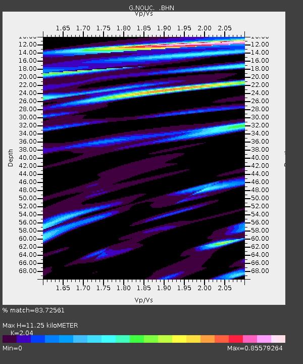
NOUC Port Laguerre, New Caledonia - Earthquake Result Viewer

Earthquake location: Unimak Island Region, Alaska
Earthquake latitude/longitude: 53.6/-164.6
Earthquake time(UTC): 2003/02/19 (050) 03:32:36 GMT
Earthquake Depth: 19 km
Earthquake Magnitude: 5.8 MB, 6.6 MS, 6.6 MW, 6.6 MW
Earthquake Catalog/Contributor: WHDF/NEIC
Network: G GEOSCOPE
Station: NOUC Port Laguerre, New Caledonia
Lat/Lon: 22.10 S/166.30 E
Elevation: 112 m
Distance: 79.5 deg
Az: 207.26 deg
Baz: 17.1 deg
Ray Param: 0.048896886
Estimated Moho Depth: 11.25 km
Estimated Crust Vp/Vs: 2.04
Assumed Crust Vp: 5.14 km/s
Estimated Crust Vs: 2.52 km/s
Estimated Crust Poisson's Ratio: 0.34
Radial Match: 83.72561 %
Radial Bump: 400
Transverse Match: 83.8653 %
Transverse Bump: 400
SOD ConfigId: 4714
Insert Time: 2010-02-26 23:35:34.951 +0000
GWidth: 2.5
Max Bumps: 400
Tol: 0.001

Signal To Noise

ChannelStoNSTALTA
G:NOUC: :BHN:20030219T03:44:10.349014Z1.12865461.7882051E-71.5843689E-7
G:NOUC: :BHE:20030219T03:44:10.349014Z0.805571.12731485E-71.3994001E-7
G:NOUC: :BHZ:20030219T03:44:10.349014Z5.1310219.231214E-71.7990989E-7
Arrivals
Ps2.3 SECOND
PpPs6.5 SECOND
PsPs/PpSs8.9 SECOND