You are here: Home > Network List > TA - USArray Transportable Network (new EarthScope stations) Stations List
> Station K39A Oelwein, IA, USA > Earthquake Result Viewer
K39A Oelwein, IA, USA - Earthquake Result Viewer
| Earthquake location: |
Peru-Bolivia Border Region |
| Earthquake latitude/longitude: |
-17.7/-69.6 |
| Earthquake time(UTC): |
2012/05/14 (135) 10:00:40 GMT |
| Earthquake Depth: |
106 km |
| Earthquake Magnitude: |
6.4 MB, 6.2 MW, 6.2 MW |
| Earthquake Catalog/Contributor: |
WHDF/NEIC |
|
| Network: |
TA USArray Transportable Network (new EarthScope stations) |
| Station: |
K39A Oelwein, IA, USA |
| Lat/Lon: |
42.71 N/91.89 W |
| Elevation: |
332 m |
|
| Distance: |
63.5 deg |
| Az: |
341.79 deg |
| Baz: |
156.16 deg |
| Ray Param: |
0.059247054 |
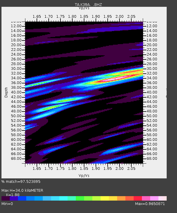
| Estimated Moho Depth: |
34.0 km |
| Estimated Crust Vp/Vs: |
1.98 |
| Assumed Crust Vp: |
6.53 km/s |
| Estimated Crust Vs: |
3.298 km/s |
| Estimated Crust Poisson's Ratio: |
0.33 |
|
| Radial Match: |
97.523895 % |
| Radial Bump: |
396 |
| Transverse Match: |
91.15006 % |
| Transverse Bump: |
400 |
| SOD ConfigId: |
446234 |
| Insert Time: |
2012-08-08 22:31:50.060 +0000 |
| GWidth: |
2.5 |
| Max Bumps: |
400 |
| Tol: |
0.001 |
|
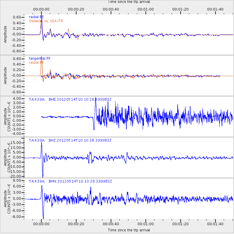
Signal To Noise
| Channel | StoN | STA | LTA |
| TA:K39A: :BHZ:20120514T10:10:28.399983Z | 79.545395 | 7.1254767E-6 | 8.957749E-8 |
| TA:K39A: :BHN:20120514T10:10:28.399983Z | 40.319855 | 3.4776385E-6 | 8.625126E-8 |
| TA:K39A: :BHE:20120514T10:10:28.399983Z | 22.820219 | 1.6391566E-6 | 7.1829135E-8 |
| Arrivals |
| Ps | 5.3 SECOND |
| PpPs | 15 SECOND |
| PsPs/PpSs | 20 SECOND |


