You are here: Home > Network List > G - GEOSCOPE Stations List
> Station NOUC Port Laguerre, New Caledonia > Earthquake Result Viewer
NOUC Port Laguerre, New Caledonia - Earthquake Result Viewer
| Earthquake location: |
Halmahera, Indonesia |
| Earthquake latitude/longitude: |
1.7/127.3 |
| Earthquake time(UTC): |
2003/03/10 (069) 02:09:37 GMT |
| Earthquake Depth: |
94 km |
| Earthquake Magnitude: |
6.2 MB, 6.4 MW, 6.4 MW |
| Earthquake Catalog/Contributor: |
WHDF/NEIC |
|
| Network: |
G GEOSCOPE |
| Station: |
NOUC Port Laguerre, New Caledonia |
| Lat/Lon: |
22.10 S/166.30 E |
| Elevation: |
112 m |
|
| Distance: |
44.8 deg |
| Az: |
124.089 deg |
| Baz: |
296.797 deg |
| Ray Param: |
0.07136335 |
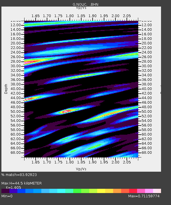
| Estimated Moho Depth: |
44.5 km |
| Estimated Crust Vp/Vs: |
1.61 |
| Assumed Crust Vp: |
5.14 km/s |
| Estimated Crust Vs: |
3.202 km/s |
| Estimated Crust Poisson's Ratio: |
0.18 |
|
| Radial Match: |
83.92923 % |
| Radial Bump: |
400 |
| Transverse Match: |
78.04154 % |
| Transverse Bump: |
400 |
| SOD ConfigId: |
4714 |
| Insert Time: |
2010-02-26 23:35:36.245 +0000 |
| GWidth: |
2.5 |
| Max Bumps: |
400 |
| Tol: |
0.001 |
|

Signal To Noise
| Channel | StoN | STA | LTA |
| G:NOUC: :BHN:20030310T02:17:11.250013Z | 2.3181784 | 4.286262E-7 | 1.8489784E-7 |
| G:NOUC: :BHE:20030310T02:17:11.250013Z | 4.3632994 | 1.8604252E-6 | 4.2638035E-7 |
| G:NOUC: :BHZ:20030310T02:17:11.250013Z | 6.4219027 | 3.0449778E-6 | 4.7415506E-7 |
| Arrivals |
| Ps | 5.5 SECOND |
| PpPs | 22 SECOND |
| PsPs/PpSs | 27 SECOND |


