You are here: Home > Network List > TA - USArray Transportable Network (new EarthScope stations) Stations List
> Station U41A Viola, AR, USA > Earthquake Result Viewer
U41A Viola, AR, USA - Earthquake Result Viewer
| Earthquake location: |
Peru-Bolivia Border Region |
| Earthquake latitude/longitude: |
-17.7/-69.6 |
| Earthquake time(UTC): |
2012/05/14 (135) 10:00:40 GMT |
| Earthquake Depth: |
106 km |
| Earthquake Magnitude: |
6.4 MB, 6.2 MW, 6.2 MW |
| Earthquake Catalog/Contributor: |
WHDF/NEIC |
|
| Network: |
TA USArray Transportable Network (new EarthScope stations) |
| Station: |
U41A Viola, AR, USA |
| Lat/Lon: |
36.34 N/91.92 W |
| Elevation: |
300 m |
|
| Distance: |
57.7 deg |
| Az: |
338.729 deg |
| Baz: |
154.635 deg |
| Ray Param: |
0.06299225 |
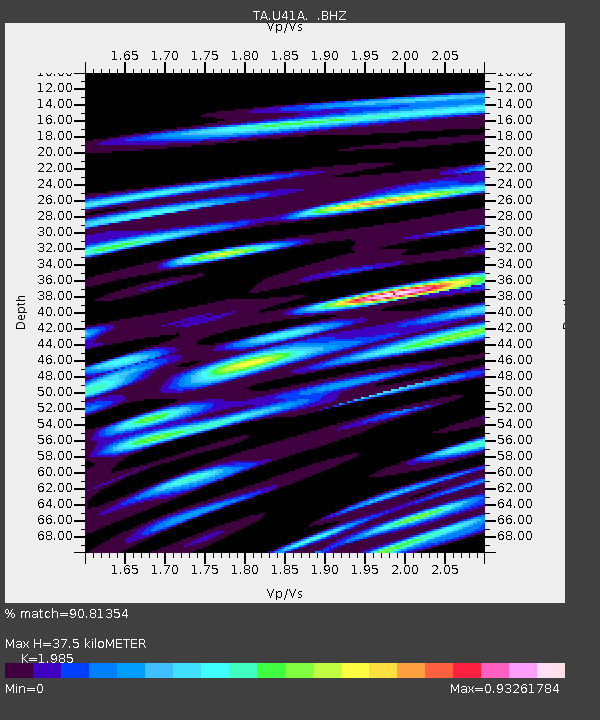
| Estimated Moho Depth: |
37.5 km |
| Estimated Crust Vp/Vs: |
1.99 |
| Assumed Crust Vp: |
6.53 km/s |
| Estimated Crust Vs: |
3.29 km/s |
| Estimated Crust Poisson's Ratio: |
0.33 |
|
| Radial Match: |
90.81354 % |
| Radial Bump: |
400 |
| Transverse Match: |
80.86584 % |
| Transverse Bump: |
400 |
| SOD ConfigId: |
446234 |
| Insert Time: |
2012-08-08 22:32:51.783 +0000 |
| GWidth: |
2.5 |
| Max Bumps: |
400 |
| Tol: |
0.001 |
|
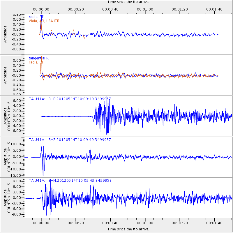
Signal To Noise
| Channel | StoN | STA | LTA |
| TA:U41A: :BHZ:20120514T10:09:49.349995Z | 63.073307 | 4.5969405E-6 | 7.28825E-8 |
| TA:U41A: :BHN:20120514T10:09:49.349995Z | 68.44593 | 3.558133E-6 | 5.1984575E-8 |
| TA:U41A: :BHE:20120514T10:09:49.349995Z | 44.609184 | 2.4582005E-6 | 5.5105257E-8 |
| Arrivals |
| Ps | 5.9 SECOND |
| PpPs | 16 SECOND |
| PsPs/PpSs | 22 SECOND |


