You are here: Home > Network List > G - GEOSCOPE Stations List
> Station NOUC Port Laguerre, New Caledonia > Earthquake Result Viewer
NOUC Port Laguerre, New Caledonia - Earthquake Result Viewer
| Earthquake location: |
Macquarie Island Region |
| Earthquake latitude/longitude: |
-58.8/158.3 |
| Earthquake time(UTC): |
1995/10/13 (286) 15:22:23 GMT |
| Earthquake Depth: |
10 km |
| Earthquake Magnitude: |
5.6 MB, 5.9 MS, 6.1 UNKNOWN, 6.1 MW |
| Earthquake Catalog/Contributor: |
WHDF/NEIC |
|
| Network: |
G GEOSCOPE |
| Station: |
NOUC Port Laguerre, New Caledonia |
| Lat/Lon: |
22.10 S/166.30 E |
| Elevation: |
112 m |
|
| Distance: |
37.1 deg |
| Az: |
12.321 deg |
| Baz: |
186.874 deg |
| Ray Param: |
0.07630023 |
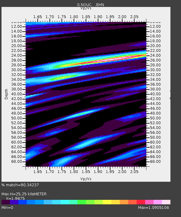
| Estimated Moho Depth: |
25.25 km |
| Estimated Crust Vp/Vs: |
1.97 |
| Assumed Crust Vp: |
5.14 km/s |
| Estimated Crust Vs: |
2.612 km/s |
| Estimated Crust Poisson's Ratio: |
0.33 |
|
| Radial Match: |
90.34237 % |
| Radial Bump: |
214 |
| Transverse Match: |
81.37627 % |
| Transverse Bump: |
400 |
| SOD ConfigId: |
4480 |
| Insert Time: |
2010-02-26 23:35:38.758 +0000 |
| GWidth: |
2.5 |
| Max Bumps: |
400 |
| Tol: |
0.001 |
|

Signal To Noise
| Channel | StoN | STA | LTA |
| G:NOUC: :BHN:19951013T15:29:03.64101Z | 5.7287283 | 1.2634947E-6 | 2.2055414E-7 |
| G:NOUC: :BHE:19951013T15:29:03.64101Z | 5.361936 | 8.413724E-7 | 1.5691579E-7 |
| G:NOUC: :BHZ:19951013T15:29:03.64101Z | 1.6049289 | 3.497298E-7 | 2.1790984E-7 |
| Arrivals |
| Ps | 5.0 SECOND |
| PpPs | 14 SECOND |
| PsPs/PpSs | 19 SECOND |


