You are here: Home > Network List > TA - USArray Transportable Network (new EarthScope stations) Stations List
> Station X42A Stuttgart, AR, USA > Earthquake Result Viewer
X42A Stuttgart, AR, USA - Earthquake Result Viewer
| Earthquake location: |
Peru-Bolivia Border Region |
| Earthquake latitude/longitude: |
-17.7/-69.6 |
| Earthquake time(UTC): |
2012/05/14 (135) 10:00:40 GMT |
| Earthquake Depth: |
106 km |
| Earthquake Magnitude: |
6.4 MB, 6.2 MW, 6.2 MW |
| Earthquake Catalog/Contributor: |
WHDF/NEIC |
|
| Network: |
TA USArray Transportable Network (new EarthScope stations) |
| Station: |
X42A Stuttgart, AR, USA |
| Lat/Lon: |
34.55 N/91.63 W |
| Elevation: |
62 m |
|
| Distance: |
56.0 deg |
| Az: |
338.071 deg |
| Baz: |
154.445 deg |
| Ray Param: |
0.064097725 |
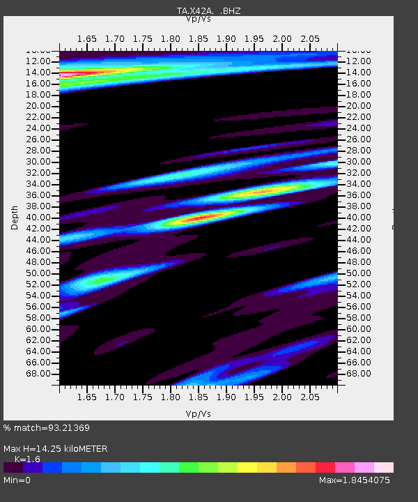
| Estimated Moho Depth: |
14.25 km |
| Estimated Crust Vp/Vs: |
1.60 |
| Assumed Crust Vp: |
6.273 km/s |
| Estimated Crust Vs: |
3.921 km/s |
| Estimated Crust Poisson's Ratio: |
0.18 |
|
| Radial Match: |
93.21369 % |
| Radial Bump: |
400 |
| Transverse Match: |
80.804146 % |
| Transverse Bump: |
400 |
| SOD ConfigId: |
446234 |
| Insert Time: |
2012-08-08 22:33:48.398 +0000 |
| GWidth: |
2.5 |
| Max Bumps: |
400 |
| Tol: |
0.001 |
|
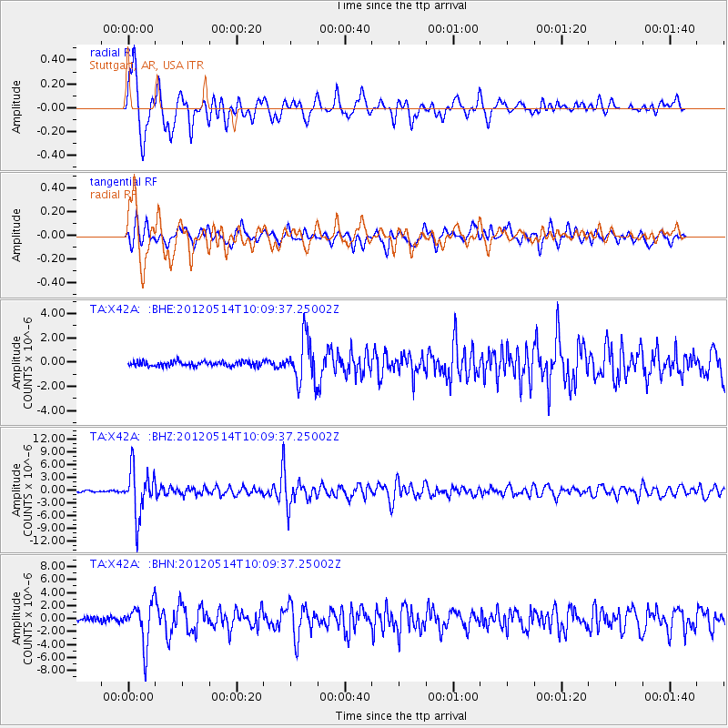
Signal To Noise
| Channel | StoN | STA | LTA |
| TA:X42A: :BHZ:20120514T10:09:37.25002Z | 36.003197 | 5.516285E-6 | 1.5321652E-7 |
| TA:X42A: :BHN:20120514T10:09:37.25002Z | 9.75238 | 3.1993593E-6 | 3.2805931E-7 |
| TA:X42A: :BHE:20120514T10:09:37.25002Z | 9.120889 | 1.8392566E-6 | 2.0165322E-7 |
| Arrivals |
| Ps | 1.4 SECOND |
| PpPs | 5.6 SECOND |
| PsPs/PpSs | 7.0 SECOND |


