You are here: Home > Network List > G - GEOSCOPE Stations List
> Station NOUC Port Laguerre, New Caledonia > Earthquake Result Viewer
NOUC Port Laguerre, New Caledonia - Earthquake Result Viewer
| Earthquake location: |
Seram, Indonesia |
| Earthquake latitude/longitude: |
-3.1/127.4 |
| Earthquake time(UTC): |
2004/01/28 (028) 22:15:30 GMT |
| Earthquake Depth: |
17 km |
| Earthquake Magnitude: |
6.0 MB, 6.5 MS, 6.7 MW, 6.6 MW |
| Earthquake Catalog/Contributor: |
WHDF/NEIC |
|
| Network: |
G GEOSCOPE |
| Station: |
NOUC Port Laguerre, New Caledonia |
| Lat/Lon: |
22.10 S/166.30 E |
| Elevation: |
112 m |
|
| Distance: |
42.2 deg |
| Az: |
119.871 deg |
| Baz: |
290.986 deg |
| Ray Param: |
0.073297136 |
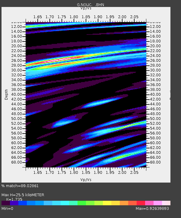
| Estimated Moho Depth: |
25.5 km |
| Estimated Crust Vp/Vs: |
1.74 |
| Assumed Crust Vp: |
5.14 km/s |
| Estimated Crust Vs: |
2.963 km/s |
| Estimated Crust Poisson's Ratio: |
0.25 |
|
| Radial Match: |
89.02861 % |
| Radial Bump: |
274 |
| Transverse Match: |
78.52594 % |
| Transverse Bump: |
400 |
| SOD ConfigId: |
2459 |
| Insert Time: |
2010-02-26 23:35:40.405 +0000 |
| GWidth: |
2.5 |
| Max Bumps: |
400 |
| Tol: |
0.001 |
|

Signal To Noise
| Channel | StoN | STA | LTA |
| G:NOUC: :BHN:20040128T22:22:51.598987Z | 1.0114341 | 2.6200055E-7 | 2.590387E-7 |
| G:NOUC: :BHE:20040128T22:22:51.598987Z | 3.5674574 | 7.2748765E-7 | 2.0392329E-7 |
| G:NOUC: :BHZ:20040128T22:22:51.598987Z | 4.191745 | 8.468406E-7 | 2.020258E-7 |
| Arrivals |
| Ps | 3.8 SECOND |
| PpPs | 13 SECOND |
| PsPs/PpSs | 17 SECOND |


