You are here: Home > Network List > TA - USArray Transportable Network (new EarthScope stations) Stations List
> Station W43A Forest City, AR, USA > Earthquake Result Viewer
W43A Forest City, AR, USA - Earthquake Result Viewer
| Earthquake location: |
Peru-Bolivia Border Region |
| Earthquake latitude/longitude: |
-17.7/-69.6 |
| Earthquake time(UTC): |
2012/05/14 (135) 10:00:40 GMT |
| Earthquake Depth: |
106 km |
| Earthquake Magnitude: |
6.4 MB, 6.2 MW, 6.2 MW |
| Earthquake Catalog/Contributor: |
WHDF/NEIC |
|
| Network: |
TA USArray Transportable Network (new EarthScope stations) |
| Station: |
W43A Forest City, AR, USA |
| Lat/Lon: |
35.09 N/90.71 W |
| Elevation: |
70 m |
|
| Distance: |
56.2 deg |
| Az: |
339.169 deg |
| Baz: |
155.581 deg |
| Ray Param: |
0.06399131 |
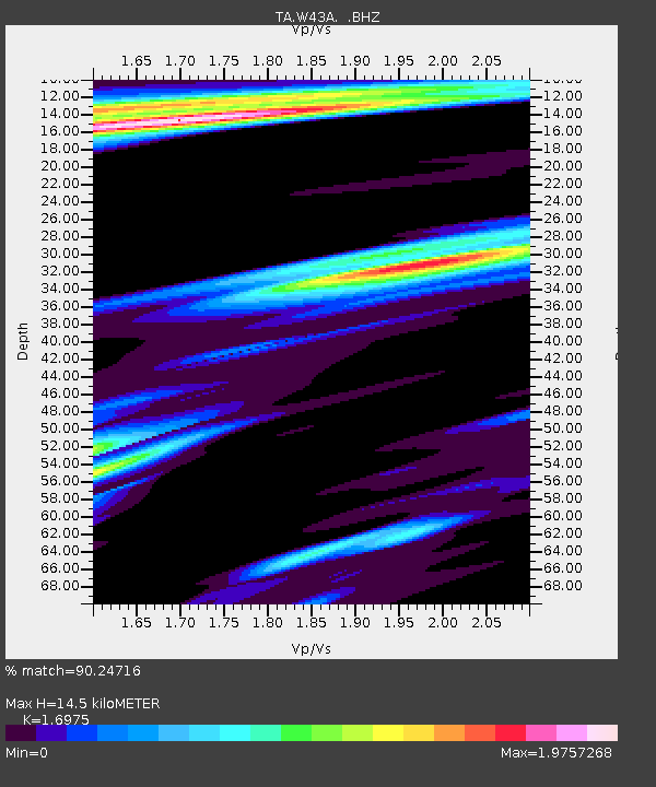
| Estimated Moho Depth: |
14.5 km |
| Estimated Crust Vp/Vs: |
1.70 |
| Assumed Crust Vp: |
6.273 km/s |
| Estimated Crust Vs: |
3.696 km/s |
| Estimated Crust Poisson's Ratio: |
0.23 |
|
| Radial Match: |
90.24716 % |
| Radial Bump: |
400 |
| Transverse Match: |
76.99722 % |
| Transverse Bump: |
400 |
| SOD ConfigId: |
446234 |
| Insert Time: |
2012-08-08 22:34:01.340 +0000 |
| GWidth: |
2.5 |
| Max Bumps: |
400 |
| Tol: |
0.001 |
|

Signal To Noise
| Channel | StoN | STA | LTA |
| TA:W43A: :BHZ:20120514T10:09:38.425007Z | 41.50964 | 6.95893E-6 | 1.676461E-7 |
| TA:W43A: :BHN:20120514T10:09:38.425007Z | 11.606907 | 4.313322E-6 | 3.7161684E-7 |
| TA:W43A: :BHE:20120514T10:09:38.425007Z | 6.4723496 | 2.2485146E-6 | 3.4740316E-7 |
| Arrivals |
| Ps | 1.7 SECOND |
| PpPs | 5.9 SECOND |
| PsPs/PpSs | 7.6 SECOND |


