You are here: Home > Network List > TA - USArray Transportable Network (new EarthScope stations) Stations List
> Station I40A Norwalk, WI, USA > Earthquake Result Viewer
I40A Norwalk, WI, USA - Earthquake Result Viewer
| Earthquake location: |
Peru-Bolivia Border Region |
| Earthquake latitude/longitude: |
-17.7/-69.6 |
| Earthquake time(UTC): |
2012/05/14 (135) 10:00:40 GMT |
| Earthquake Depth: |
106 km |
| Earthquake Magnitude: |
6.4 MB, 6.2 MW, 6.2 MW |
| Earthquake Catalog/Contributor: |
WHDF/NEIC |
|
| Network: |
TA USArray Transportable Network (new EarthScope stations) |
| Station: |
I40A Norwalk, WI, USA |
| Lat/Lon: |
43.89 N/90.62 W |
| Elevation: |
419 m |
|
| Distance: |
64.2 deg |
| Az: |
343.258 deg |
| Baz: |
157.675 deg |
| Ray Param: |
0.05877683 |
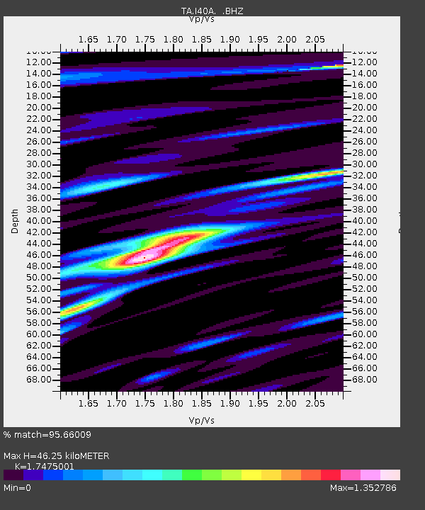
| Estimated Moho Depth: |
46.25 km |
| Estimated Crust Vp/Vs: |
1.75 |
| Assumed Crust Vp: |
6.53 km/s |
| Estimated Crust Vs: |
3.737 km/s |
| Estimated Crust Poisson's Ratio: |
0.26 |
|
| Radial Match: |
95.66009 % |
| Radial Bump: |
400 |
| Transverse Match: |
82.21133 % |
| Transverse Bump: |
400 |
| SOD ConfigId: |
446234 |
| Insert Time: |
2012-08-08 22:34:23.015 +0000 |
| GWidth: |
2.5 |
| Max Bumps: |
400 |
| Tol: |
0.001 |
|

Signal To Noise
| Channel | StoN | STA | LTA |
| TA:I40A: :BHZ:20120514T10:10:33.149983Z | 64.45253 | 5.7071015E-6 | 8.854735E-8 |
| TA:I40A: :BHN:20120514T10:10:33.149983Z | 38.369534 | 2.9477565E-6 | 7.6825444E-8 |
| TA:I40A: :BHE:20120514T10:10:33.149983Z | 19.527449 | 1.3539583E-6 | 6.933615E-8 |
| Arrivals |
| Ps | 5.5 SECOND |
| PpPs | 19 SECOND |
| PsPs/PpSs | 24 SECOND |


