You are here: Home > Network List > TA - USArray Transportable Network (new EarthScope stations) Stations List
> Station G38A Ridgeland, WI, USA > Earthquake Result Viewer
G38A Ridgeland, WI, USA - Earthquake Result Viewer
| Earthquake location: |
Peru-Bolivia Border Region |
| Earthquake latitude/longitude: |
-17.7/-69.6 |
| Earthquake time(UTC): |
2012/05/14 (135) 10:00:40 GMT |
| Earthquake Depth: |
106 km |
| Earthquake Magnitude: |
6.4 MB, 6.2 MW, 6.2 MW |
| Earthquake Catalog/Contributor: |
WHDF/NEIC |
|
| Network: |
TA USArray Transportable Network (new EarthScope stations) |
| Station: |
G38A Ridgeland, WI, USA |
| Lat/Lon: |
45.17 N/91.85 W |
| Elevation: |
370 m |
|
| Distance: |
65.7 deg |
| Az: |
342.905 deg |
| Baz: |
156.661 deg |
| Ray Param: |
0.057787716 |
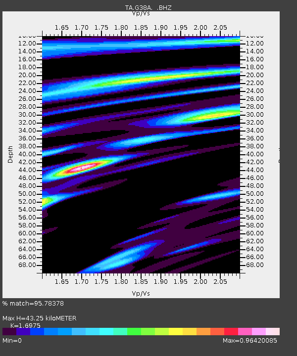
| Estimated Moho Depth: |
43.25 km |
| Estimated Crust Vp/Vs: |
1.70 |
| Assumed Crust Vp: |
6.571 km/s |
| Estimated Crust Vs: |
3.871 km/s |
| Estimated Crust Poisson's Ratio: |
0.23 |
|
| Radial Match: |
95.78378 % |
| Radial Bump: |
400 |
| Transverse Match: |
88.141304 % |
| Transverse Bump: |
400 |
| SOD ConfigId: |
446234 |
| Insert Time: |
2012-08-08 22:35:33.090 +0000 |
| GWidth: |
2.5 |
| Max Bumps: |
400 |
| Tol: |
0.001 |
|

Signal To Noise
| Channel | StoN | STA | LTA |
| TA:G38A: :BHZ:20120514T10:10:42.974995Z | 68.22017 | 4.408784E-6 | 6.4625816E-8 |
| TA:G38A: :BHN:20120514T10:10:42.974995Z | 33.660057 | 1.8873615E-6 | 5.6071247E-8 |
| TA:G38A: :BHE:20120514T10:10:42.974995Z | 15.037262 | 7.996859E-7 | 5.3180287E-8 |
| Arrivals |
| Ps | 4.8 SECOND |
| PpPs | 17 SECOND |
| PsPs/PpSs | 22 SECOND |


