You are here: Home > Network List > G - GEOSCOPE Stations List
> Station NOUC Port Laguerre, New Caledonia > Earthquake Result Viewer
NOUC Port Laguerre, New Caledonia - Earthquake Result Viewer
| Earthquake location: |
Irian Jaya, Indonesia |
| Earthquake latitude/longitude: |
-3.7/140.3 |
| Earthquake time(UTC): |
1995/12/19 (353) 23:28:12 GMT |
| Earthquake Depth: |
71 km |
| Earthquake Magnitude: |
6.2 MB, 6.5 UNKNOWN |
| Earthquake Catalog/Contributor: |
WHDF/NEIC |
|
| Network: |
G GEOSCOPE |
| Station: |
NOUC Port Laguerre, New Caledonia |
| Lat/Lon: |
22.10 S/166.30 E |
| Elevation: |
112 m |
|
| Distance: |
31.2 deg |
| Az: |
128.17 deg |
| Baz: |
302.222 deg |
| Ray Param: |
0.07901531 |
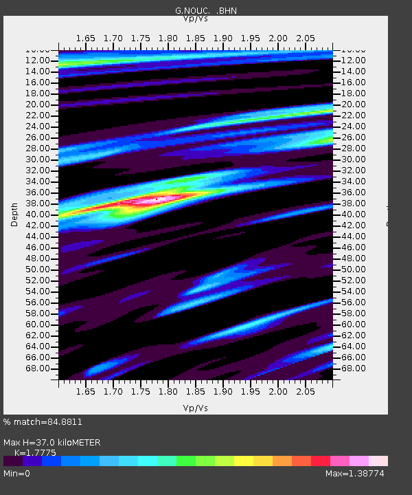
| Estimated Moho Depth: |
37.0 km |
| Estimated Crust Vp/Vs: |
1.78 |
| Assumed Crust Vp: |
5.14 km/s |
| Estimated Crust Vs: |
2.892 km/s |
| Estimated Crust Poisson's Ratio: |
0.27 |
|
| Radial Match: |
84.8811 % |
| Radial Bump: |
400 |
| Transverse Match: |
62.37267 % |
| Transverse Bump: |
400 |
| SOD ConfigId: |
4480 |
| Insert Time: |
2010-02-26 23:35:49.048 +0000 |
| GWidth: |
2.5 |
| Max Bumps: |
400 |
| Tol: |
0.001 |
|
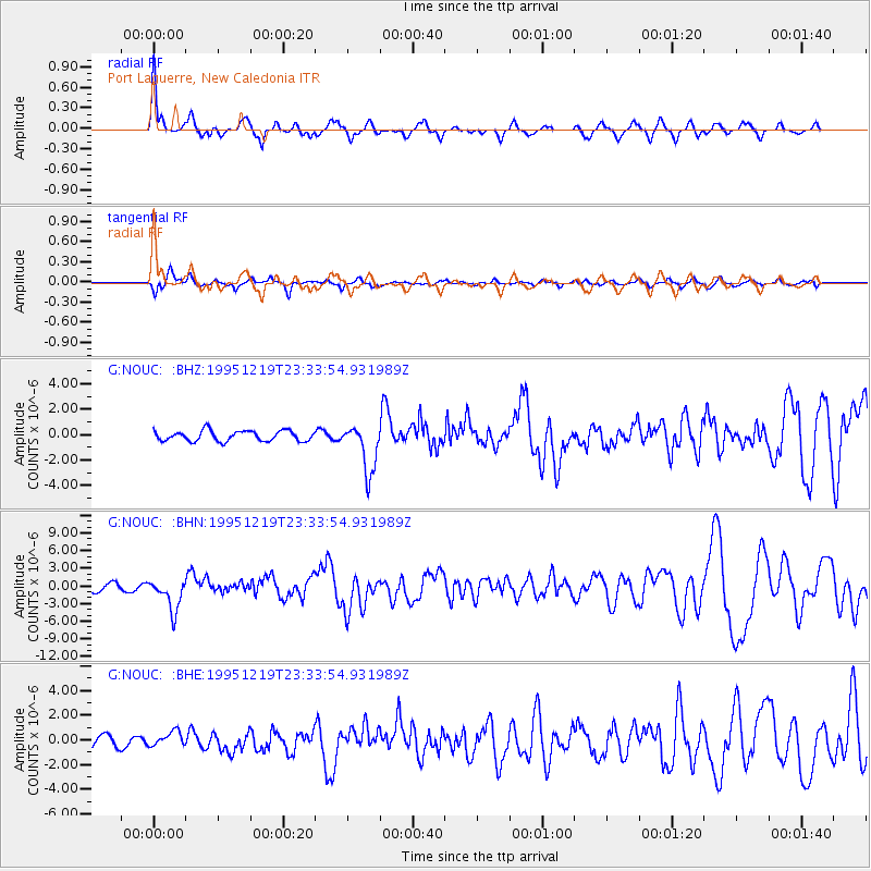
Signal To Noise
| Channel | StoN | STA | LTA |
| G:NOUC: :BHN:19951219T23:33:54.931989Z | 3.5431051 | 2.698944E-6 | 7.6174535E-7 |
| G:NOUC: :BHE:19951219T23:33:54.931989Z | 1.2634633 | 6.2188917E-7 | 4.922099E-7 |
| G:NOUC: :BHZ:19951219T23:33:54.931989Z | 4.710917 | 1.9037024E-6 | 4.0410444E-7 |
| Arrivals |
| Ps | 5.9 SECOND |
| PpPs | 19 SECOND |
| PsPs/PpSs | 25 SECOND |


