You are here: Home > Network List > TA - USArray Transportable Network (new EarthScope stations) Stations List
> Station E40A Wakefield, MI, USA > Earthquake Result Viewer
E40A Wakefield, MI, USA - Earthquake Result Viewer
| Earthquake location: |
Peru-Bolivia Border Region |
| Earthquake latitude/longitude: |
-17.7/-69.6 |
| Earthquake time(UTC): |
2012/05/14 (135) 10:00:40 GMT |
| Earthquake Depth: |
106 km |
| Earthquake Magnitude: |
6.4 MB, 6.2 MW, 6.2 MW |
| Earthquake Catalog/Contributor: |
WHDF/NEIC |
|
| Network: |
TA USArray Transportable Network (new EarthScope stations) |
| Station: |
E40A Wakefield, MI, USA |
| Lat/Lon: |
46.44 N/89.90 W |
| Elevation: |
472 m |
|
| Distance: |
66.4 deg |
| Az: |
344.818 deg |
| Baz: |
158.835 deg |
| Ray Param: |
0.057352863 |
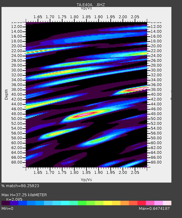
| Estimated Moho Depth: |
37.25 km |
| Estimated Crust Vp/Vs: |
2.09 |
| Assumed Crust Vp: |
6.467 km/s |
| Estimated Crust Vs: |
3.102 km/s |
| Estimated Crust Poisson's Ratio: |
0.35 |
|
| Radial Match: |
98.25923 % |
| Radial Bump: |
364 |
| Transverse Match: |
93.76701 % |
| Transverse Bump: |
400 |
| SOD ConfigId: |
446234 |
| Insert Time: |
2012-08-08 22:37:19.970 +0000 |
| GWidth: |
2.5 |
| Max Bumps: |
400 |
| Tol: |
0.001 |
|

Signal To Noise
| Channel | StoN | STA | LTA |
| TA:E40A: :BHZ:20120514T10:10:47.199971Z | 95.47606 | 8.564609E-6 | 8.970426E-8 |
| TA:E40A: :BHN:20120514T10:10:47.199971Z | 78.27937 | 4.9262544E-6 | 6.2931704E-8 |
| TA:E40A: :BHE:20120514T10:10:47.199971Z | 39.200935 | 9.839755E-7 | 2.5100817E-8 |
| Arrivals |
| Ps | 6.5 SECOND |
| PpPs | 17 SECOND |
| PsPs/PpSs | 24 SECOND |


