You are here: Home > Network List > G - GEOSCOPE Stations List
> Station NOUC Port Laguerre, New Caledonia > Earthquake Result Viewer
NOUC Port Laguerre, New Caledonia - Earthquake Result Viewer
| Earthquake location: |
Banda Sea |
| Earthquake latitude/longitude: |
-6.9/129.2 |
| Earthquake time(UTC): |
1995/12/25 (359) 04:43:24 GMT |
| Earthquake Depth: |
150 km |
| Earthquake Magnitude: |
6.2 MB, 7.1 UNKNOWN, 7.1 MW |
| Earthquake Catalog/Contributor: |
WHDF/NEIC |
|
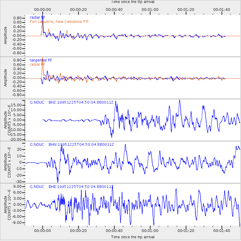
| Network: |
G GEOSCOPE |
| Station: |
NOUC Port Laguerre, New Caledonia |
| Lat/Lon: |
22.10 S/166.30 E |
| Elevation: |
112 m |
|
| Distance: |
38.8 deg |
| Az: |
116.787 deg |
| Baz: |
287.136 deg |
| Ray Param: |
0.07479742 |
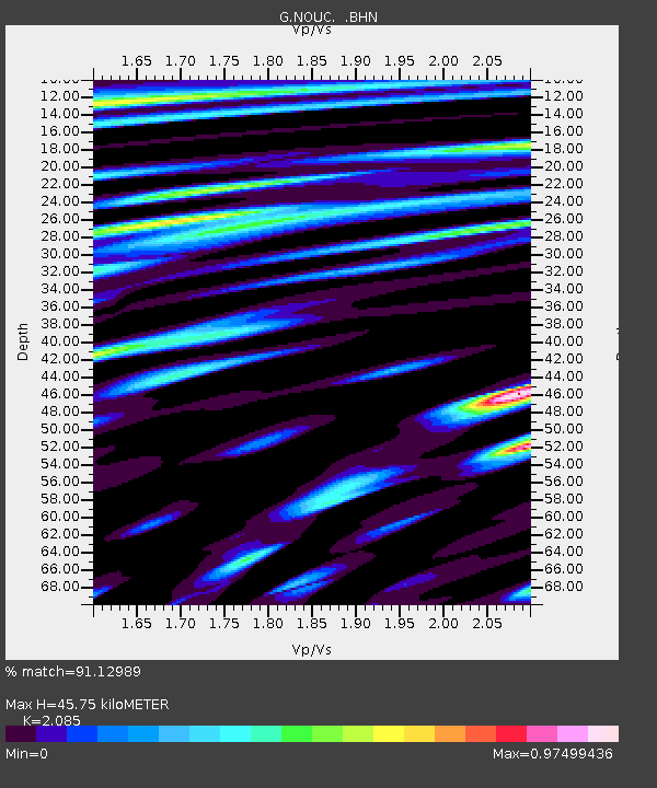
| Estimated Moho Depth: |
45.75 km |
| Estimated Crust Vp/Vs: |
2.09 |
| Assumed Crust Vp: |
5.14 km/s |
| Estimated Crust Vs: |
2.465 km/s |
| Estimated Crust Poisson's Ratio: |
0.35 |
|
| Radial Match: |
91.12989 % |
| Radial Bump: |
400 |
| Transverse Match: |
84.23569 % |
| Transverse Bump: |
400 |
| SOD ConfigId: |
4480 |
| Insert Time: |
2010-02-26 23:35:50.900 +0000 |
| GWidth: |
2.5 |
| Max Bumps: |
400 |
| Tol: |
0.001 |
|
Signal To Noise
| Channel | StoN | STA | LTA |
| G:NOUC: :BHN:19951225T04:50:04.880011Z | 3.3655646 | 2.8013517E-6 | 8.3235716E-7 |
| G:NOUC: :BHE:19951225T04:50:04.880011Z | 0.59466624 | 6.169719E-7 | 1.0375095E-6 |
| G:NOUC: :BHZ:19951225T04:50:04.880011Z | 3.5584934 | 2.0217271E-6 | 5.6814133E-7 |
| Arrivals |
| Ps | 10 SECOND |
| PpPs | 26 SECOND |
| PsPs/PpSs | 36 SECOND |


