You are here: Home > Network List > TA - USArray Transportable Network (new EarthScope stations) Stations List
> Station F44A Big Bay de Noc Black Bears, Cooks, MI, USA > Earthquake Result Viewer
F44A Big Bay de Noc Black Bears, Cooks, MI, USA - Earthquake Result Viewer
| Earthquake location: |
Peru-Bolivia Border Region |
| Earthquake latitude/longitude: |
-17.7/-69.6 |
| Earthquake time(UTC): |
2012/05/14 (135) 10:00:40 GMT |
| Earthquake Depth: |
106 km |
| Earthquake Magnitude: |
6.4 MB, 6.2 MW, 6.2 MW |
| Earthquake Catalog/Contributor: |
WHDF/NEIC |
|
| Network: |
TA USArray Transportable Network (new EarthScope stations) |
| Station: |
F44A Big Bay de Noc Black Bears, Cooks, MI, USA |
| Lat/Lon: |
45.97 N/86.42 W |
| Elevation: |
234 m |
|
| Distance: |
65.2 deg |
| Az: |
347.143 deg |
| Baz: |
162.29 deg |
| Ray Param: |
0.058169063 |
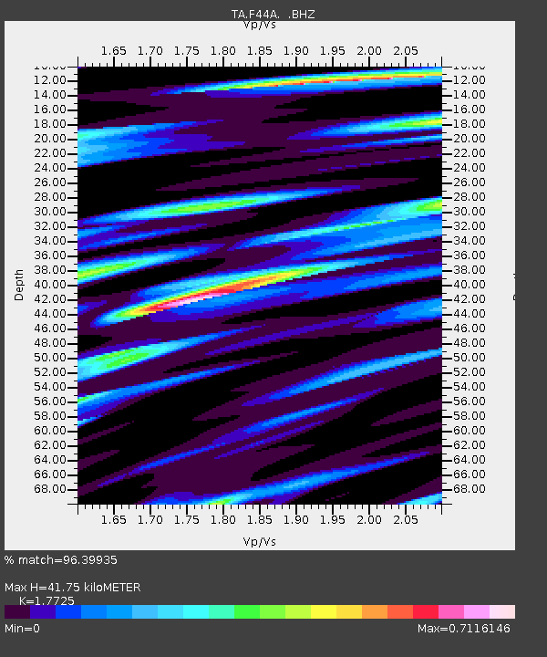
| Estimated Moho Depth: |
41.75 km |
| Estimated Crust Vp/Vs: |
1.77 |
| Assumed Crust Vp: |
6.53 km/s |
| Estimated Crust Vs: |
3.684 km/s |
| Estimated Crust Poisson's Ratio: |
0.27 |
|
| Radial Match: |
96.39935 % |
| Radial Bump: |
400 |
| Transverse Match: |
88.421684 % |
| Transverse Bump: |
400 |
| SOD ConfigId: |
446234 |
| Insert Time: |
2012-08-08 22:38:01.348 +0000 |
| GWidth: |
2.5 |
| Max Bumps: |
400 |
| Tol: |
0.001 |
|
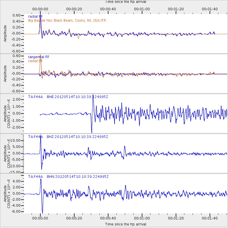
Signal To Noise
| Channel | StoN | STA | LTA |
| TA:F44A: :BHZ:20120514T10:10:39.224995Z | 58.27256 | 5.3441663E-6 | 9.170983E-8 |
| TA:F44A: :BHN:20120514T10:10:39.224995Z | 30.226336 | 2.4515455E-6 | 8.110628E-8 |
| TA:F44A: :BHE:20120514T10:10:39.224995Z | 16.261864 | 1.1380536E-6 | 6.9982974E-8 |
| Arrivals |
| Ps | 5.2 SECOND |
| PpPs | 17 SECOND |
| PsPs/PpSs | 22 SECOND |


