You are here: Home > Network List > TA - USArray Transportable Network (new EarthScope stations) Stations List
> Station C40A Isle Royale National Park, MI, USA > Earthquake Result Viewer
C40A Isle Royale National Park, MI, USA - Earthquake Result Viewer
| Earthquake location: |
Peru-Bolivia Border Region |
| Earthquake latitude/longitude: |
-17.7/-69.6 |
| Earthquake time(UTC): |
2012/05/14 (135) 10:00:40 GMT |
| Earthquake Depth: |
106 km |
| Earthquake Magnitude: |
6.4 MB, 6.2 MW, 6.2 MW |
| Earthquake Catalog/Contributor: |
WHDF/NEIC |
|
| Network: |
TA USArray Transportable Network (new EarthScope stations) |
| Station: |
C40A Isle Royale National Park, MI, USA |
| Lat/Lon: |
47.92 N/89.15 W |
| Elevation: |
216 m |
|
| Distance: |
67.6 deg |
| Az: |
345.901 deg |
| Baz: |
159.804 deg |
| Ray Param: |
0.056574583 |
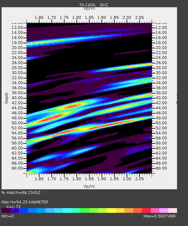
| Estimated Moho Depth: |
54.25 km |
| Estimated Crust Vp/Vs: |
1.72 |
| Assumed Crust Vp: |
6.467 km/s |
| Estimated Crust Vs: |
3.76 km/s |
| Estimated Crust Poisson's Ratio: |
0.24 |
|
| Radial Match: |
96.23452 % |
| Radial Bump: |
400 |
| Transverse Match: |
91.76936 % |
| Transverse Bump: |
400 |
| SOD ConfigId: |
446234 |
| Insert Time: |
2012-08-08 22:38:27.552 +0000 |
| GWidth: |
2.5 |
| Max Bumps: |
400 |
| Tol: |
0.001 |
|
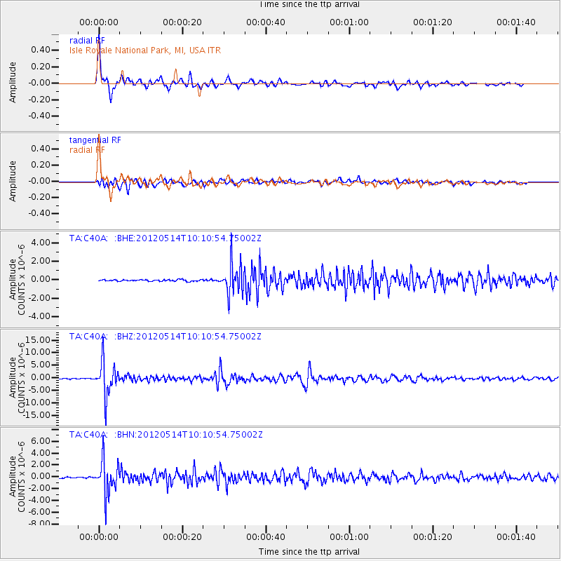
Signal To Noise
| Channel | StoN | STA | LTA |
| TA:C40A: :BHZ:20120514T10:10:54.75002Z | 51.07389 | 6.8175345E-6 | 1.3348375E-7 |
| TA:C40A: :BHN:20120514T10:10:54.75002Z | 27.735641 | 2.8850247E-6 | 1.04018675E-7 |
| TA:C40A: :BHE:20120514T10:10:54.75002Z | 21.639925 | 1.6740698E-6 | 7.736024E-8 |
| Arrivals |
| Ps | 6.3 SECOND |
| PpPs | 22 SECOND |
| PsPs/PpSs | 28 SECOND |


