You are here: Home > Network List > TA - USArray Transportable Network (new EarthScope stations) Stations List
> Station K42A Prairie Point, Evansville, WI, USA > Earthquake Result Viewer
K42A Prairie Point, Evansville, WI, USA - Earthquake Result Viewer
| Earthquake location: |
Peru-Bolivia Border Region |
| Earthquake latitude/longitude: |
-17.7/-69.6 |
| Earthquake time(UTC): |
2012/05/14 (135) 10:00:40 GMT |
| Earthquake Depth: |
106 km |
| Earthquake Magnitude: |
6.4 MB, 6.2 MW, 6.2 MW |
| Earthquake Catalog/Contributor: |
WHDF/NEIC |
|
| Network: |
TA USArray Transportable Network (new EarthScope stations) |
| Station: |
K42A Prairie Point, Evansville, WI, USA |
| Lat/Lon: |
42.78 N/89.35 W |
| Elevation: |
302 m |
|
| Distance: |
62.8 deg |
| Az: |
343.76 deg |
| Baz: |
158.768 deg |
| Ray Param: |
0.05966873 |
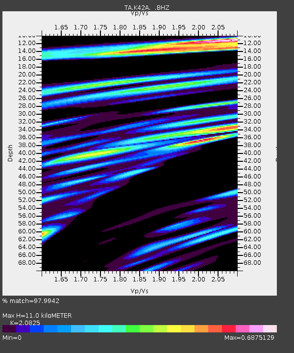
| Estimated Moho Depth: |
11.0 km |
| Estimated Crust Vp/Vs: |
2.08 |
| Assumed Crust Vp: |
6.571 km/s |
| Estimated Crust Vs: |
3.155 km/s |
| Estimated Crust Poisson's Ratio: |
0.35 |
|
| Radial Match: |
97.9942 % |
| Radial Bump: |
400 |
| Transverse Match: |
93.194145 % |
| Transverse Bump: |
400 |
| SOD ConfigId: |
446234 |
| Insert Time: |
2012-08-08 22:39:06.988 +0000 |
| GWidth: |
2.5 |
| Max Bumps: |
400 |
| Tol: |
0.001 |
|
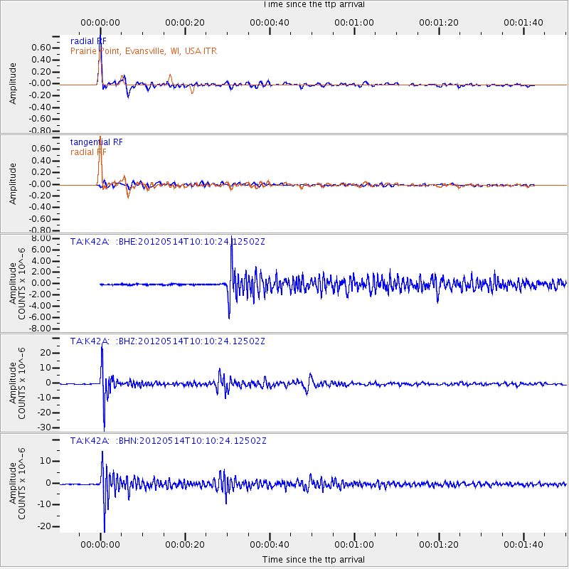
Signal To Noise
| Channel | StoN | STA | LTA |
| TA:K42A: :BHZ:20120514T10:10:24.12502Z | 108.91509 | 9.728566E-6 | 8.932248E-8 |
| TA:K42A: :BHN:20120514T10:10:24.12502Z | 79.44 | 6.87866E-6 | 8.6589374E-8 |
| TA:K42A: :BHE:20120514T10:10:24.12502Z | 35.97712 | 2.7019335E-6 | 7.510144E-8 |
| Arrivals |
| Ps | 1.9 SECOND |
| PpPs | 5.0 SECOND |
| PsPs/PpSs | 6.8 SECOND |


