You are here: Home > Network List > G - GEOSCOPE Stations List
> Station NOUC Port Laguerre, New Caledonia > Earthquake Result Viewer
NOUC Port Laguerre, New Caledonia - Earthquake Result Viewer

| Earthquake location: |
Mariana Islands |
| Earthquake latitude/longitude: |
15.7/146.6 |
| Earthquake time(UTC): |
1993/06/06 (157) 13:23:27 GMT |
| Earthquake Depth: |
68 km |
| Earthquake Magnitude: |
5.8 MB, 6.4 UNKNOWN |
| Earthquake Catalog/Contributor: |
WHDF/NEIC |
|
| Network: |
G GEOSCOPE |
| Station: |
NOUC Port Laguerre, New Caledonia |
| Lat/Lon: |
22.10 S/166.30 E |
| Elevation: |
112 m |
|
| Distance: |
42.2 deg |
| Az: |
152.243 deg |
| Baz: |
331.071 deg |
| Ray Param: |
0.07309964 |
| Estimated Moho Depth: |
12.0 km |
| Estimated Crust Vp/Vs: |
2.09 |
| Assumed Crust Vp: |
5.14 km/s |
| Estimated Crust Vs: |
2.456 km/s |
| Estimated Crust Poisson's Ratio: |
0.35 |
|
| Radial Match: |
85.45924 % |
| Radial Bump: |
372 |
| Transverse Match: |
84.86924 % |
| Transverse Bump: |
400 |
| SOD ConfigId: |
4480 |
| Insert Time: |
2010-02-26 23:35:54.288 +0000 |
| GWidth: |
2.5 |
| Max Bumps: |
400 |
| Tol: |
0.001 |
|
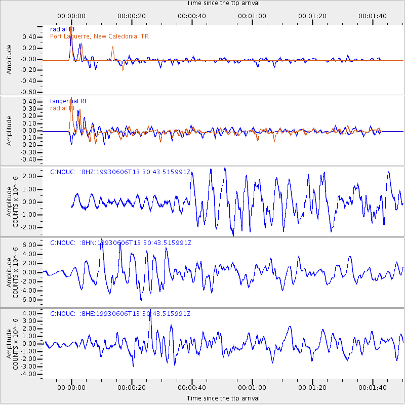
Signal To Noise
| Channel | StoN | STA | LTA |
| G:NOUC: :BHN:19930606T13:30:43.515991Z | 4.237208 | 1.7386918E-6 | 4.1033903E-7 |
| G:NOUC: :BHE:19930606T13:30:43.515991Z | 1.4483728 | 3.270804E-7 | 2.258261E-7 |
| G:NOUC: :BHZ:19930606T13:30:43.515991Z | 1.0317653 | 3.122448E-7 | 3.0263163E-7 |
| Arrivals |
| Ps | 2.6 SECOND |
| PpPs | 7.0 SECOND |
| PsPs/PpSs | 9.6 SECOND |


