You are here: Home > Network List > TA - USArray Transportable Network (new EarthScope stations) Stations List
> Station M45A Boilermakers Shaker, Crown Point, IN, USA > Earthquake Result Viewer
M45A Boilermakers Shaker, Crown Point, IN, USA - Earthquake Result Viewer
| Earthquake location: |
Peru-Bolivia Border Region |
| Earthquake latitude/longitude: |
-17.7/-69.6 |
| Earthquake time(UTC): |
2012/05/14 (135) 10:00:40 GMT |
| Earthquake Depth: |
106 km |
| Earthquake Magnitude: |
6.4 MB, 6.2 MW, 6.2 MW |
| Earthquake Catalog/Contributor: |
WHDF/NEIC |
|
| Network: |
TA USArray Transportable Network (new EarthScope stations) |
| Station: |
M45A Boilermakers Shaker, Crown Point, IN, USA |
| Lat/Lon: |
41.39 N/87.25 W |
| Elevation: |
216 m |
|
| Distance: |
61.0 deg |
| Az: |
344.872 deg |
| Baz: |
160.691 deg |
| Ray Param: |
0.060856897 |
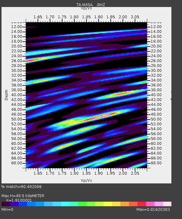
| Estimated Moho Depth: |
48.5 km |
| Estimated Crust Vp/Vs: |
1.91 |
| Assumed Crust Vp: |
6.498 km/s |
| Estimated Crust Vs: |
3.402 km/s |
| Estimated Crust Poisson's Ratio: |
0.31 |
|
| Radial Match: |
90.482086 % |
| Radial Bump: |
400 |
| Transverse Match: |
74.59863 % |
| Transverse Bump: |
400 |
| SOD ConfigId: |
446234 |
| Insert Time: |
2012-08-08 22:39:59.888 +0000 |
| GWidth: |
2.5 |
| Max Bumps: |
400 |
| Tol: |
0.001 |
|

Signal To Noise
| Channel | StoN | STA | LTA |
| TA:M45A: :BHZ:20120514T10:10:11.800007Z | 38.169052 | 4.0795207E-6 | 1.0688033E-7 |
| TA:M45A: :BHN:20120514T10:10:11.800007Z | 17.613892 | 2.1812953E-6 | 1.238395E-7 |
| TA:M45A: :BHE:20120514T10:10:11.800007Z | 8.770466 | 1.1337436E-6 | 1.2926833E-7 |
| Arrivals |
| Ps | 7.1 SECOND |
| PpPs | 21 SECOND |
| PsPs/PpSs | 28 SECOND |


