You are here: Home > Network List > TA - USArray Transportable Network (new EarthScope stations) Stations List
> Station Q45A Warren Harvey, Newton, IL, USA > Earthquake Result Viewer
Q45A Warren Harvey, Newton, IL, USA - Earthquake Result Viewer
| Earthquake location: |
Peru-Bolivia Border Region |
| Earthquake latitude/longitude: |
-17.7/-69.6 |
| Earthquake time(UTC): |
2012/05/14 (135) 10:00:40 GMT |
| Earthquake Depth: |
106 km |
| Earthquake Magnitude: |
6.4 MB, 6.2 MW, 6.2 MW |
| Earthquake Catalog/Contributor: |
WHDF/NEIC |
|
| Network: |
TA USArray Transportable Network (new EarthScope stations) |
| Station: |
Q45A Warren Harvey, Newton, IL, USA |
| Lat/Lon: |
38.89 N/88.16 W |
| Elevation: |
162 m |
|
| Distance: |
58.9 deg |
| Az: |
343.133 deg |
| Baz: |
159.238 deg |
| Ray Param: |
0.062229924 |
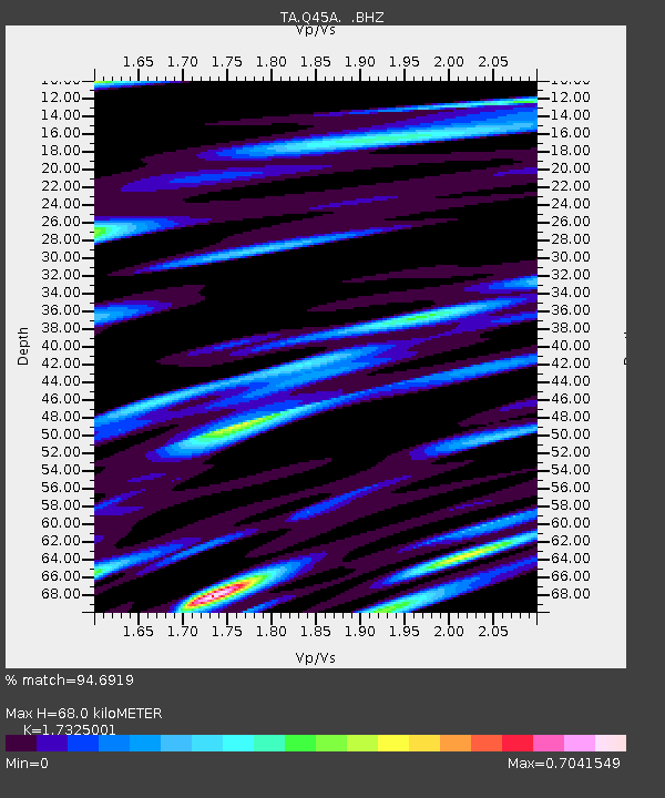
| Estimated Moho Depth: |
68.0 km |
| Estimated Crust Vp/Vs: |
1.73 |
| Assumed Crust Vp: |
6.444 km/s |
| Estimated Crust Vs: |
3.719 km/s |
| Estimated Crust Poisson's Ratio: |
0.25 |
|
| Radial Match: |
94.6919 % |
| Radial Bump: |
400 |
| Transverse Match: |
86.90961 % |
| Transverse Bump: |
400 |
| SOD ConfigId: |
446234 |
| Insert Time: |
2012-08-08 22:40:52.555 +0000 |
| GWidth: |
2.5 |
| Max Bumps: |
400 |
| Tol: |
0.001 |
|

Signal To Noise
| Channel | StoN | STA | LTA |
| TA:Q45A: :BHZ:20120514T10:09:57.474995Z | 62.686108 | 5.8520764E-6 | 9.335524E-8 |
| TA:Q45A: :BHN:20120514T10:09:57.474995Z | 30.729189 | 2.6617631E-6 | 8.662003E-8 |
| TA:Q45A: :BHE:20120514T10:09:57.474995Z | 13.929858 | 1.3264771E-6 | 9.522545E-8 |
| Arrivals |
| Ps | 8.1 SECOND |
| PpPs | 27 SECOND |
| PsPs/PpSs | 36 SECOND |


