You are here: Home > Network List > TA - USArray Transportable Network (new EarthScope stations) Stations List
> Station R47A Wooly Knot Farm, English, IN, USA > Earthquake Result Viewer
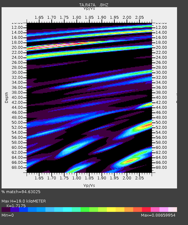
R47A Wooly Knot Farm, English, IN, USA - Earthquake Result Viewer
| Earthquake location: |
Peru-Bolivia Border Region |
| Earthquake latitude/longitude: |
-17.7/-69.6 |
| Earthquake time(UTC): |
2012/05/14 (135) 10:00:40 GMT |
| Earthquake Depth: |
106 km |
| Earthquake Magnitude: |
6.4 MB, 6.2 MW, 6.2 MW |
| Earthquake Catalog/Contributor: |
WHDF/NEIC |
|
| Network: |
TA USArray Transportable Network (new EarthScope stations) |
| Station: |
R47A Wooly Knot Farm, English, IN, USA |
| Lat/Lon: |
38.30 N/86.53 W |
| Elevation: |
181 m |
|
| Distance: |
57.9 deg |
| Az: |
344.302 deg |
| Baz: |
160.863 deg |
| Ray Param: |
0.062879734 |
| Estimated Moho Depth: |
19.0 km |
| Estimated Crust Vp/Vs: |
1.72 |
| Assumed Crust Vp: |
6.444 km/s |
| Estimated Crust Vs: |
3.752 km/s |
| Estimated Crust Poisson's Ratio: |
0.24 |
|
| Radial Match: |
94.63025 % |
| Radial Bump: |
400 |
| Transverse Match: |
89.32405 % |
| Transverse Bump: |
400 |
| SOD ConfigId: |
446234 |
| Insert Time: |
2012-08-08 22:41:51.863 +0000 |
| GWidth: |
2.5 |
| Max Bumps: |
400 |
| Tol: |
0.001 |
|

Signal To Noise
| Channel | StoN | STA | LTA |
| TA:R47A: :BHZ:20120514T10:09:50.550007Z | 52.314075 | 5.6738936E-6 | 1.0845826E-7 |
| TA:R47A: :BHN:20120514T10:09:50.550007Z | 23.108316 | 2.0919572E-6 | 9.052833E-8 |
| TA:R47A: :BHE:20120514T10:09:50.550007Z | 11.701803 | 8.8981915E-7 | 7.60412E-8 |
| Arrivals |
| Ps | 2.2 SECOND |
| PpPs | 7.6 SECOND |
| PsPs/PpSs | 9.8 SECOND |


