You are here: Home > Network List > G - GEOSCOPE Stations List
> Station NOUC Port Laguerre, New Caledonia > Earthquake Result Viewer
NOUC Port Laguerre, New Caledonia - Earthquake Result Viewer
| Earthquake location: |
Near East Coast Of Kamchatka |
| Earthquake latitude/longitude: |
51.2/157.8 |
| Earthquake time(UTC): |
1993/06/08 (159) 13:03:37 GMT |
| Earthquake Depth: |
81 km |
| Earthquake Magnitude: |
6.4 MB, 7.3 MS |
| Earthquake Catalog/Contributor: |
WHDF/NEIC |
|
| Network: |
G GEOSCOPE |
| Station: |
NOUC Port Laguerre, New Caledonia |
| Lat/Lon: |
22.10 S/166.30 E |
| Elevation: |
112 m |
|
| Distance: |
73.4 deg |
| Az: |
171.807 deg |
| Baz: |
354.454 deg |
| Ray Param: |
0.052858997 |
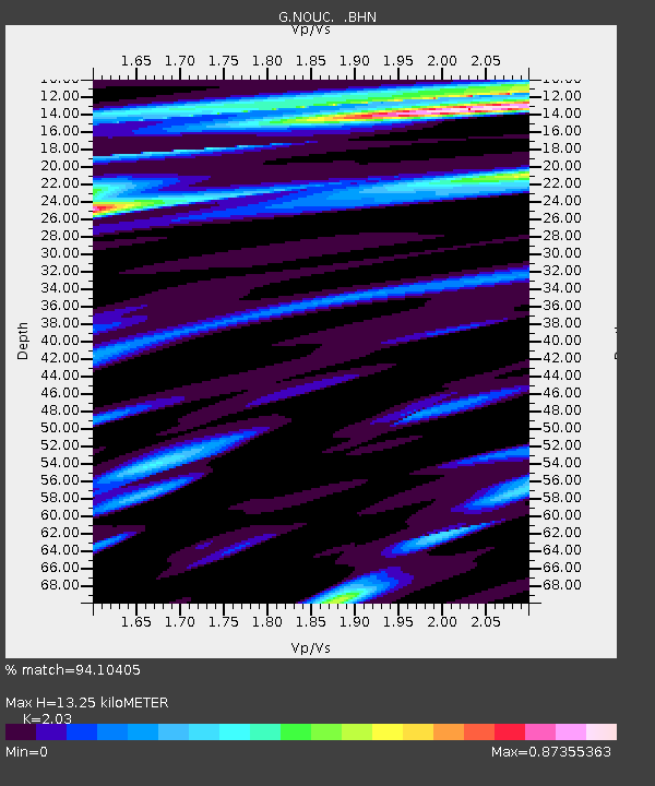
| Estimated Moho Depth: |
13.25 km |
| Estimated Crust Vp/Vs: |
2.03 |
| Assumed Crust Vp: |
5.14 km/s |
| Estimated Crust Vs: |
2.532 km/s |
| Estimated Crust Poisson's Ratio: |
0.34 |
|
| Radial Match: |
94.10405 % |
| Radial Bump: |
353 |
| Transverse Match: |
91.29958 % |
| Transverse Bump: |
400 |
| SOD ConfigId: |
16938 |
| Insert Time: |
2010-02-26 23:35:58.812 +0000 |
| GWidth: |
2.5 |
| Max Bumps: |
400 |
| Tol: |
0.001 |
|

Signal To Noise
| Channel | StoN | STA | LTA |
| G:NOUC: :BHN:19930608T13:14:29.899011Z | 1.0260097 | 3.462795E-7 | 3.3750118E-7 |
| G:NOUC: :BHE:19930608T13:14:29.899011Z | 0.91635543 | 3.853684E-7 | 4.2054467E-7 |
| G:NOUC: :BHZ:19930608T13:14:29.899011Z | 2.546121 | 9.740537E-7 | 3.8256383E-7 |
| Arrivals |
| Ps | 2.7 SECOND |
| PpPs | 7.7 SECOND |
| PsPs/PpSs | 10 SECOND |


