You are here: Home > Network List > G - GEOSCOPE Stations List
> Station NOUC Port Laguerre, New Caledonia > Earthquake Result Viewer
NOUC Port Laguerre, New Caledonia - Earthquake Result Viewer
| Earthquake location: |
South Of Mariana Islands |
| Earthquake latitude/longitude: |
13.0/144.8 |
| Earthquake time(UTC): |
1993/08/08 (220) 08:34:25 GMT |
| Earthquake Depth: |
61 km |
| Earthquake Magnitude: |
7.2 MB, 8.1 MS, 8.2 UNKNOWN, 7.5 MW |
| Earthquake Catalog/Contributor: |
WHDF/NEIC |
|
| Network: |
G GEOSCOPE |
| Station: |
NOUC Port Laguerre, New Caledonia |
| Lat/Lon: |
22.10 S/166.30 E |
| Elevation: |
112 m |
|
| Distance: |
40.7 deg |
| Az: |
148.576 deg |
| Baz: |
326.767 deg |
| Ray Param: |
0.074040554 |
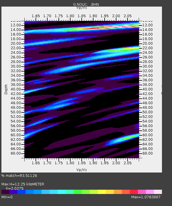
| Estimated Moho Depth: |
12.25 km |
| Estimated Crust Vp/Vs: |
2.03 |
| Assumed Crust Vp: |
5.14 km/s |
| Estimated Crust Vs: |
2.535 km/s |
| Estimated Crust Poisson's Ratio: |
0.34 |
|
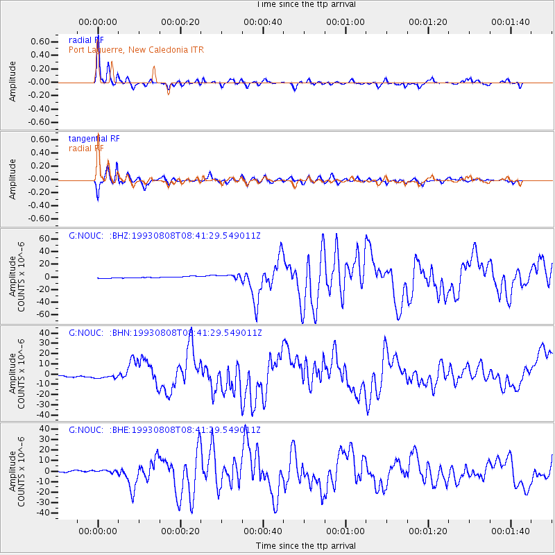
| Radial Match: |
93.51126 % |
| Radial Bump: |
359 |
| Transverse Match: |
91.31314 % |
| Transverse Bump: |
376 |
| SOD ConfigId: |
16938 |
| Insert Time: |
2010-02-26 23:36:01.018 +0000 |
| GWidth: |
2.5 |
| Max Bumps: |
400 |
| Tol: |
0.001 |
|
Signal To Noise
| Channel | StoN | STA | LTA |
| G:NOUC: :BHN:19930808T08:41:29.549011Z | 2.8053753 | 1.9203533E-6 | 6.845263E-7 |
| G:NOUC: :BHE:19930808T08:41:29.549011Z | 1.8769484 | 1.2703E-6 | 6.7679E-7 |
| G:NOUC: :BHZ:19930808T08:41:29.549011Z | 2.8231173 | 3.2123883E-6 | 1.1378869E-6 |
| Arrivals |
| Ps | 2.5 SECOND |
| PpPs | 7.0 SECOND |
| PsPs/PpSs | 9.5 SECOND |


