You are here: Home > Network List > TA - USArray Transportable Network (new EarthScope stations) Stations List
> Station Y49A New Hope, AL, USA > Earthquake Result Viewer
Y49A New Hope, AL, USA - Earthquake Result Viewer

| Earthquake location: |
Peru-Bolivia Border Region |
| Earthquake latitude/longitude: |
-17.7/-69.6 |
| Earthquake time(UTC): |
2012/05/14 (135) 10:00:40 GMT |
| Earthquake Depth: |
106 km |
| Earthquake Magnitude: |
6.4 MB, 6.2 MW, 6.2 MW |
| Earthquake Catalog/Contributor: |
WHDF/NEIC |
|
| Network: |
TA USArray Transportable Network (new EarthScope stations) |
| Station: |
Y49A New Hope, AL, USA |
| Lat/Lon: |
33.86 N/86.41 W |
| Elevation: |
362 m |
|
| Distance: |
53.7 deg |
| Az: |
342.615 deg |
| Baz: |
159.982 deg |
| Ray Param: |
0.06559189 |
| Estimated Moho Depth: |
36.25 km |
| Estimated Crust Vp/Vs: |
2.08 |
| Assumed Crust Vp: |
6.565 km/s |
| Estimated Crust Vs: |
3.164 km/s |
| Estimated Crust Poisson's Ratio: |
0.35 |
|
| Radial Match: |
93.75662 % |
| Radial Bump: |
400 |
| Transverse Match: |
87.15795 % |
| Transverse Bump: |
400 |
| SOD ConfigId: |
446234 |
| Insert Time: |
2012-08-08 22:43:00.937 +0000 |
| GWidth: |
2.5 |
| Max Bumps: |
400 |
| Tol: |
0.001 |
|
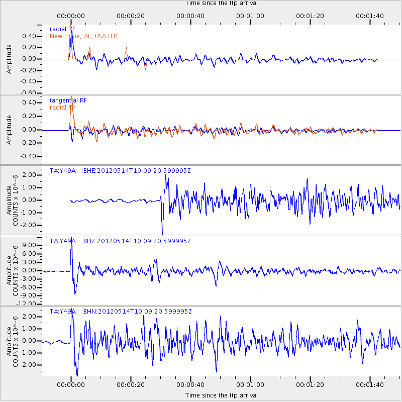
Signal To Noise
| Channel | StoN | STA | LTA |
| TA:Y49A: :BHZ:20120514T10:09:20.599995Z | 37.204575 | 4.270189E-6 | 1.14775915E-7 |
| TA:Y49A: :BHN:20120514T10:09:20.599995Z | 15.047671 | 1.4481813E-6 | 9.623956E-8 |
| TA:Y49A: :BHE:20120514T10:09:20.599995Z | 13.915057 | 1.0823804E-6 | 7.778483E-8 |
| Arrivals |
| Ps | 6.2 SECOND |
| PpPs | 16 SECOND |
| PsPs/PpSs | 22 SECOND |


