You are here: Home > Network List > G - GEOSCOPE Stations List
> Station NOUC Port Laguerre, New Caledonia > Earthquake Result Viewer
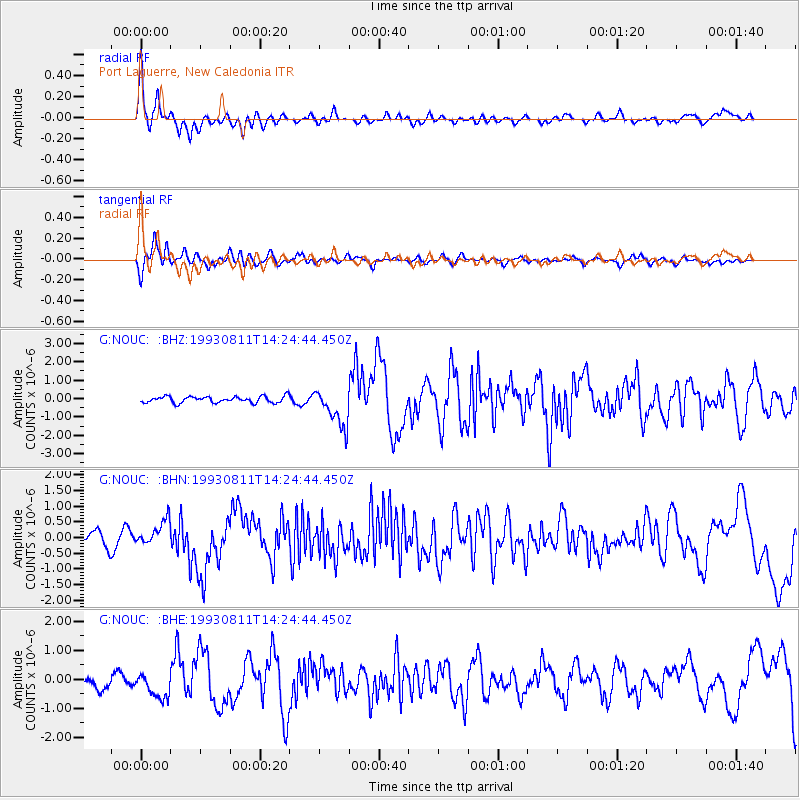
NOUC Port Laguerre, New Caledonia - Earthquake Result Viewer

| Earthquake location: |
Mariana Islands |
| Earthquake latitude/longitude: |
13.1/145.6 |
| Earthquake time(UTC): |
1993/08/11 (223) 14:17:41 GMT |
| Earthquake Depth: |
56 km |
| Earthquake Magnitude: |
6.0 MB, 6.2 MS, 6.1 UNKNOWN, 6.2 MW |
| Earthquake Catalog/Contributor: |
WHDF/NEIC |
|
| Network: |
G GEOSCOPE |
| Station: |
NOUC Port Laguerre, New Caledonia |
| Lat/Lon: |
22.10 S/166.30 E |
| Elevation: |
112 m |
|
| Distance: |
40.5 deg |
| Az: |
149.684 deg |
| Baz: |
327.979 deg |
| Ray Param: |
0.07423145 |
| Estimated Moho Depth: |
22.5 km |
| Estimated Crust Vp/Vs: |
1.60 |
| Assumed Crust Vp: |
5.14 km/s |
| Estimated Crust Vs: |
3.212 km/s |
| Estimated Crust Poisson's Ratio: |
0.18 |
|
| Radial Match: |
87.17645 % |
| Radial Bump: |
400 |
| Transverse Match: |
78.077156 % |
| Transverse Bump: |
400 |
| SOD ConfigId: |
16938 |
| Insert Time: |
2010-02-26 23:36:02.162 +0000 |
| GWidth: |
2.5 |
| Max Bumps: |
400 |
| Tol: |
0.001 |
|
Signal To Noise
| Channel | StoN | STA | LTA |
| G:NOUC: :BHN:19930811T14:24:44.450Z | 2.1223712 | 4.0737964E-7 | 1.9194553E-7 |
| G:NOUC: :BHE:19930811T14:24:44.450Z | 2.2919183 | 4.3344784E-7 | 1.8912012E-7 |
| G:NOUC: :BHZ:19930811T14:24:44.450Z | 6.1258903 | 1.0472884E-6 | 1.70961E-7 |
| Arrivals |
| Ps | 2.8 SECOND |
| PpPs | 11 SECOND |
| PsPs/PpSs | 14 SECOND |


