You are here: Home > Network List > TA - USArray Transportable Network (new EarthScope stations) Stations List
> Station W47A Westpoint, TN, USA > Earthquake Result Viewer
W47A Westpoint, TN, USA - Earthquake Result Viewer
| Earthquake location: |
Peru-Bolivia Border Region |
| Earthquake latitude/longitude: |
-17.7/-69.6 |
| Earthquake time(UTC): |
2012/05/14 (135) 10:00:40 GMT |
| Earthquake Depth: |
106 km |
| Earthquake Magnitude: |
6.4 MB, 6.2 MW, 6.2 MW |
| Earthquake Catalog/Contributor: |
WHDF/NEIC |
|
| Network: |
TA USArray Transportable Network (new EarthScope stations) |
| Station: |
W47A Westpoint, TN, USA |
| Lat/Lon: |
35.25 N/87.59 W |
| Elevation: |
293 m |
|
| Distance: |
55.3 deg |
| Az: |
342.09 deg |
| Baz: |
159.009 deg |
| Ray Param: |
0.06453125 |
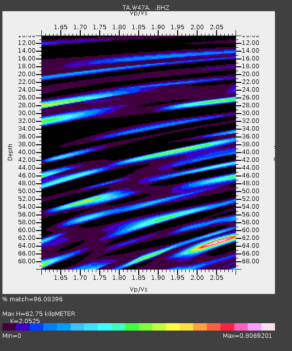
| Estimated Moho Depth: |
62.75 km |
| Estimated Crust Vp/Vs: |
2.05 |
| Assumed Crust Vp: |
6.476 km/s |
| Estimated Crust Vs: |
3.155 km/s |
| Estimated Crust Poisson's Ratio: |
0.34 |
|
| Radial Match: |
96.08396 % |
| Radial Bump: |
400 |
| Transverse Match: |
83.57587 % |
| Transverse Bump: |
400 |
| SOD ConfigId: |
446234 |
| Insert Time: |
2012-08-08 22:44:46.655 +0000 |
| GWidth: |
2.5 |
| Max Bumps: |
400 |
| Tol: |
0.001 |
|
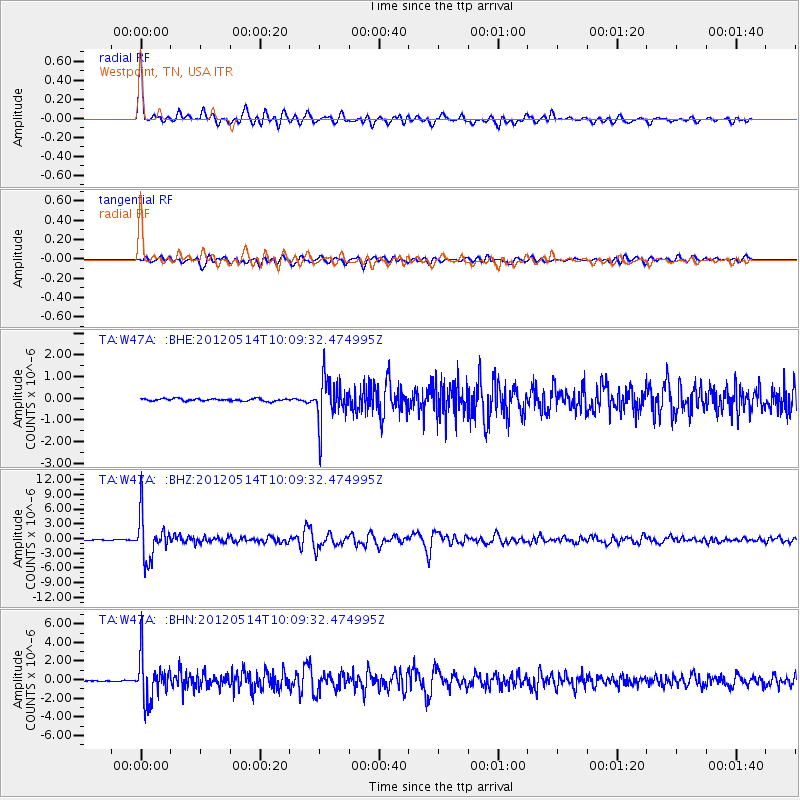
Signal To Noise
| Channel | StoN | STA | LTA |
| TA:W47A: :BHZ:20120514T10:09:32.474995Z | 88.35431 | 4.3328964E-6 | 4.9040015E-8 |
| TA:W47A: :BHN:20120514T10:09:32.474995Z | 54.19177 | 2.3236794E-6 | 4.2878824E-8 |
| TA:W47A: :BHE:20120514T10:09:32.474995Z | 18.132322 | 9.857747E-7 | 5.4365607E-8 |
| Arrivals |
| Ps | 11 SECOND |
| PpPs | 28 SECOND |
| PsPs/PpSs | 39 SECOND |


