You are here: Home > Network List > G - GEOSCOPE Stations List
> Station NOUC Port Laguerre, New Caledonia > Earthquake Result Viewer
NOUC Port Laguerre, New Caledonia - Earthquake Result Viewer
| Earthquake location: |
Banda Sea |
| Earthquake latitude/longitude: |
-6.1/128.9 |
| Earthquake time(UTC): |
1993/10/05 (278) 05:09:49 GMT |
| Earthquake Depth: |
37 km |
| Earthquake Magnitude: |
5.9 MB, 6.1 MS, 6.4 UNKNOWN, 6.4 MW |
| Earthquake Catalog/Contributor: |
WHDF/NEIC |
|
| Network: |
G GEOSCOPE |
| Station: |
NOUC Port Laguerre, New Caledonia |
| Lat/Lon: |
22.10 S/166.30 E |
| Elevation: |
112 m |
|
| Distance: |
39.4 deg |
| Az: |
117.548 deg |
| Baz: |
288.079 deg |
| Ray Param: |
0.07491313 |
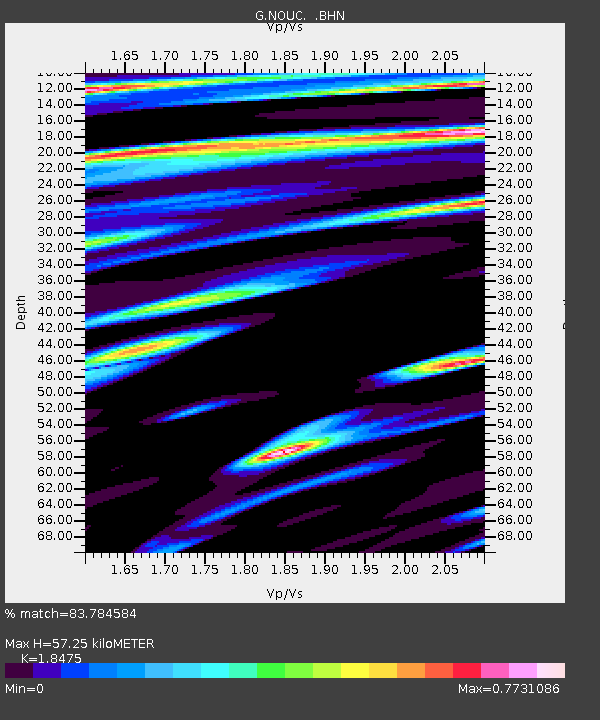
| Estimated Moho Depth: |
57.25 km |
| Estimated Crust Vp/Vs: |
1.85 |
| Assumed Crust Vp: |
5.14 km/s |
| Estimated Crust Vs: |
2.782 km/s |
| Estimated Crust Poisson's Ratio: |
0.29 |
|
| Radial Match: |
83.784584 % |
| Radial Bump: |
325 |
| Transverse Match: |
74.96264 % |
| Transverse Bump: |
395 |
| SOD ConfigId: |
16938 |
| Insert Time: |
2010-02-26 23:36:06.531 +0000 |
| GWidth: |
2.5 |
| Max Bumps: |
400 |
| Tol: |
0.001 |
|
Signal To Noise
| Channel | StoN | STA | LTA |
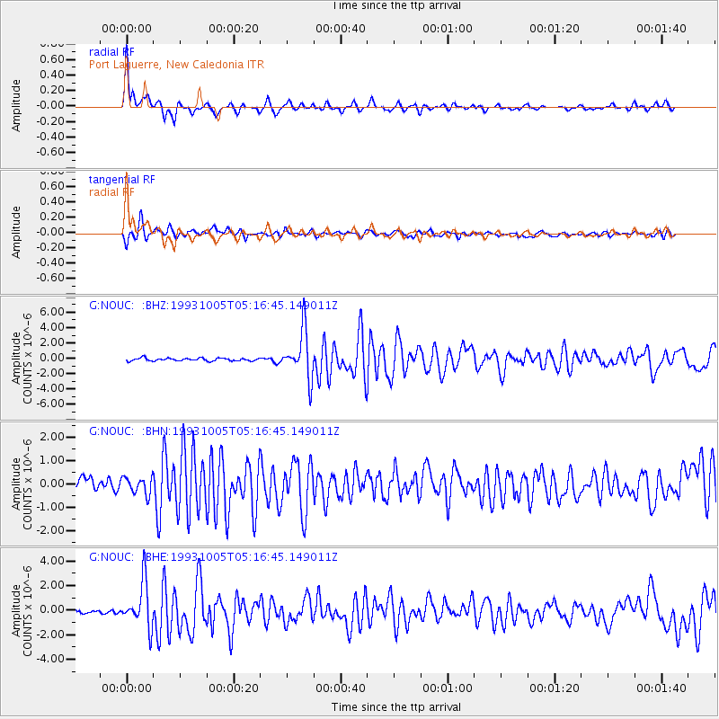
| G:NOUC: :BHN:19931005T05:16:45.149011Z | 1.6922481 | 3.6453037E-7 | 2.1541189E-7 |
| G:NOUC: :BHE:19931005T05:16:45.149011Z | 9.28027 | 1.8676373E-6 | 2.0124816E-7 |
| G:NOUC: :BHZ:19931005T05:16:45.149011Z | 17.171406 | 3.1508507E-6 | 1.8349405E-7 |
| Arrivals |
| Ps | 9.8 SECOND |
| PpPs | 30 SECOND |
| PsPs/PpSs | 40 SECOND |


