You are here: Home > Network List > TA - USArray Transportable Network (new EarthScope stations) Stations List
> Station 452A Marianna, FL, USA > Earthquake Result Viewer
452A Marianna, FL, USA - Earthquake Result Viewer
| Earthquake location: |
Peru-Bolivia Border Region |
| Earthquake latitude/longitude: |
-17.7/-69.6 |
| Earthquake time(UTC): |
2012/05/14 (135) 10:00:40 GMT |
| Earthquake Depth: |
106 km |
| Earthquake Magnitude: |
6.4 MB, 6.2 MW, 6.2 MW |
| Earthquake Catalog/Contributor: |
WHDF/NEIC |
|
| Network: |
TA USArray Transportable Network (new EarthScope stations) |
| Station: |
452A Marianna, FL, USA |
| Lat/Lon: |
30.85 N/85.18 W |
| Elevation: |
35 m |
|
| Distance: |
50.5 deg |
| Az: |
342.574 deg |
| Baz: |
160.611 deg |
| Ray Param: |
0.06765362 |
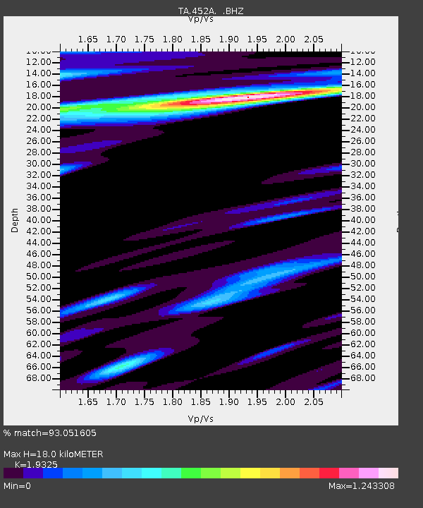
| Estimated Moho Depth: |
18.0 km |
| Estimated Crust Vp/Vs: |
1.93 |
| Assumed Crust Vp: |
6.347 km/s |
| Estimated Crust Vs: |
3.284 km/s |
| Estimated Crust Poisson's Ratio: |
0.32 |
|
| Radial Match: |
93.051605 % |
| Radial Bump: |
400 |
| Transverse Match: |
80.402336 % |
| Transverse Bump: |
400 |
| SOD ConfigId: |
446234 |
| Insert Time: |
2012-08-08 22:45:28.988 +0000 |
| GWidth: |
2.5 |
| Max Bumps: |
400 |
| Tol: |
0.001 |
|
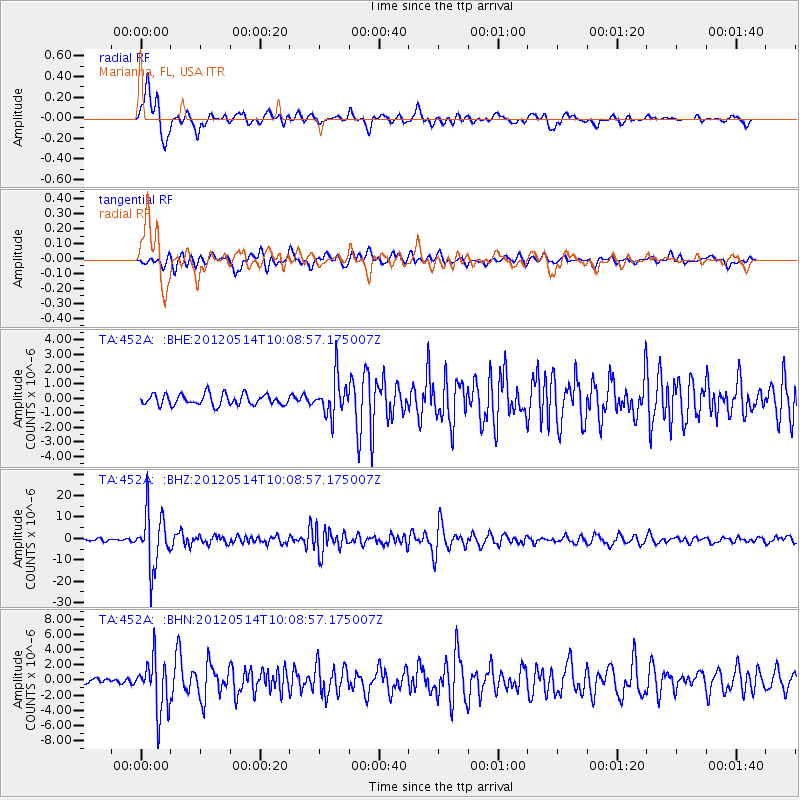
Signal To Noise
| Channel | StoN | STA | LTA |
| TA:452A: :BHZ:20120514T10:08:57.175007Z | 34.81026 | 1.2718155E-5 | 3.653565E-7 |
| TA:452A: :BHN:20120514T10:08:57.175007Z | 8.888099 | 3.5106114E-6 | 3.949789E-7 |
| TA:452A: :BHE:20120514T10:08:57.175007Z | 3.414269 | 1.2758742E-6 | 3.7368883E-7 |
| Arrivals |
| Ps | 2.8 SECOND |
| PpPs | 7.9 SECOND |
| PsPs/PpSs | 11 SECOND |


