You are here: Home > Network List > TA - USArray Transportable Network (new EarthScope stations) Stations List
> Station 456A Hilliard, FL, USA > Earthquake Result Viewer
456A Hilliard, FL, USA - Earthquake Result Viewer
| Earthquake location: |
Peru-Bolivia Border Region |
| Earthquake latitude/longitude: |
-17.7/-69.6 |
| Earthquake time(UTC): |
2012/05/14 (135) 10:00:40 GMT |
| Earthquake Depth: |
106 km |
| Earthquake Magnitude: |
6.4 MB, 6.2 MW, 6.2 MW |
| Earthquake Catalog/Contributor: |
WHDF/NEIC |
|
| Network: |
TA USArray Transportable Network (new EarthScope stations) |
| Station: |
456A Hilliard, FL, USA |
| Lat/Lon: |
30.72 N/82.02 W |
| Elevation: |
26 m |
|
| Distance: |
49.6 deg |
| Az: |
345.909 deg |
| Baz: |
164.363 deg |
| Ray Param: |
0.068264015 |
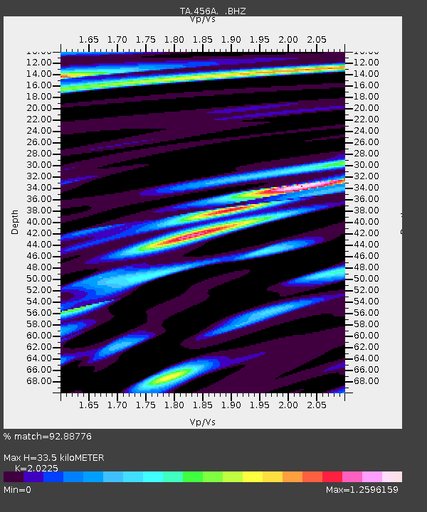
| Estimated Moho Depth: |
33.5 km |
| Estimated Crust Vp/Vs: |
2.02 |
| Assumed Crust Vp: |
6.565 km/s |
| Estimated Crust Vs: |
3.246 km/s |
| Estimated Crust Poisson's Ratio: |
0.34 |
|
| Radial Match: |
92.88776 % |
| Radial Bump: |
400 |
| Transverse Match: |
80.95517 % |
| Transverse Bump: |
400 |
| SOD ConfigId: |
446234 |
| Insert Time: |
2012-08-08 22:45:45.734 +0000 |
| GWidth: |
2.5 |
| Max Bumps: |
400 |
| Tol: |
0.001 |
|
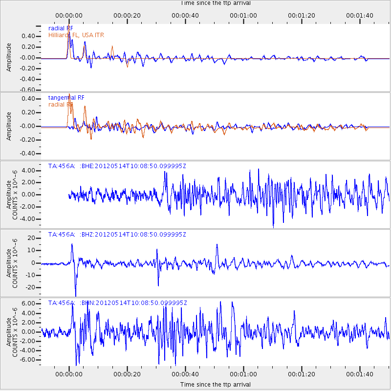
Signal To Noise
| Channel | StoN | STA | LTA |
| TA:456A: :BHZ:20120514T10:08:50.099995Z | 16.985897 | 8.328754E-6 | 4.903335E-7 |
| TA:456A: :BHN:20120514T10:08:50.099995Z | 6.279717 | 2.9357113E-6 | 4.6749105E-7 |
| TA:456A: :BHE:20120514T10:08:50.099995Z | 2.6701288 | 1.6158828E-6 | 6.051703E-7 |
| Arrivals |
| Ps | 5.5 SECOND |
| PpPs | 15 SECOND |
| PsPs/PpSs | 20 SECOND |


