You are here: Home > Network List > TA - USArray Transportable Network (new EarthScope stations) Stations List
> Station 657A Interlachen, FL, USA > Earthquake Result Viewer
657A Interlachen, FL, USA - Earthquake Result Viewer
| Earthquake location: |
Peru-Bolivia Border Region |
| Earthquake latitude/longitude: |
-17.7/-69.6 |
| Earthquake time(UTC): |
2012/05/14 (135) 10:00:40 GMT |
| Earthquake Depth: |
106 km |
| Earthquake Magnitude: |
6.4 MB, 6.2 MW, 6.2 MW |
| Earthquake Catalog/Contributor: |
WHDF/NEIC |
|
| Network: |
TA USArray Transportable Network (new EarthScope stations) |
| Station: |
657A Interlachen, FL, USA |
| Lat/Lon: |
29.59 N/81.87 W |
| Elevation: |
34 m |
|
| Distance: |
48.5 deg |
| Az: |
345.674 deg |
| Baz: |
164.287 deg |
| Ray Param: |
0.06898474 |
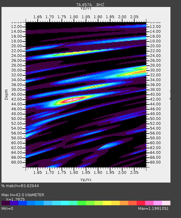
| Estimated Moho Depth: |
42.0 km |
| Estimated Crust Vp/Vs: |
1.79 |
| Assumed Crust Vp: |
6.134 km/s |
| Estimated Crust Vs: |
3.422 km/s |
| Estimated Crust Poisson's Ratio: |
0.27 |
|
| Radial Match: |
93.82844 % |
| Radial Bump: |
384 |
| Transverse Match: |
77.67136 % |
| Transverse Bump: |
400 |
| SOD ConfigId: |
446234 |
| Insert Time: |
2012-08-08 22:46:34.756 +0000 |
| GWidth: |
2.5 |
| Max Bumps: |
400 |
| Tol: |
0.001 |
|
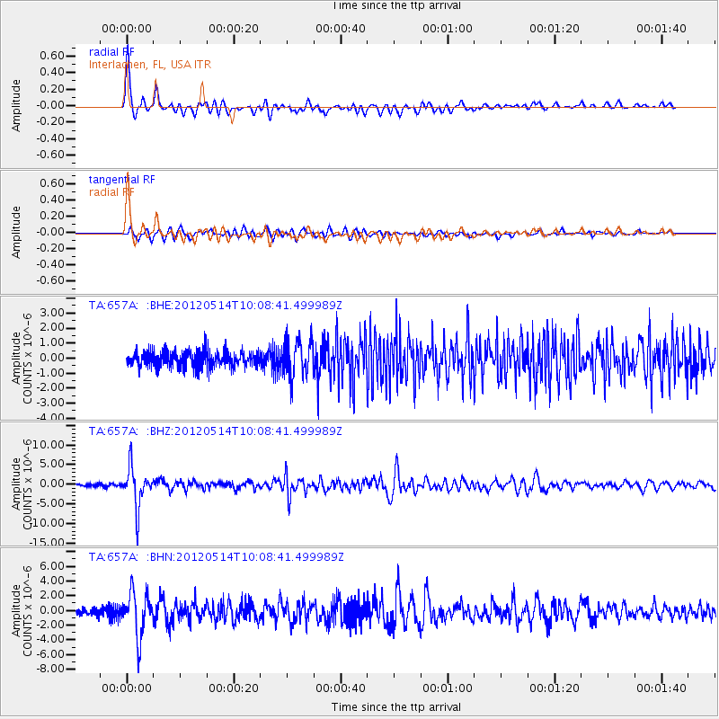
Signal To Noise
| Channel | StoN | STA | LTA |
| TA:657A: :BHZ:20120514T10:08:41.499989Z | 17.152609 | 5.1036304E-6 | 2.9754253E-7 |
| TA:657A: :BHN:20120514T10:08:41.499989Z | 4.7145104 | 2.9871928E-6 | 6.336168E-7 |
| TA:657A: :BHE:20120514T10:08:41.499989Z | 2.253052 | 1.2022646E-6 | 5.33616E-7 |
| Arrivals |
| Ps | 5.7 SECOND |
| PpPs | 18 SECOND |
| PsPs/PpSs | 24 SECOND |


