You are here: Home > Network List > TA - USArray Transportable Network (new EarthScope stations) Stations List
> Station 757A Oxford, FL, USA > Earthquake Result Viewer
757A Oxford, FL, USA - Earthquake Result Viewer
| Earthquake location: |
Peru-Bolivia Border Region |
| Earthquake latitude/longitude: |
-17.7/-69.6 |
| Earthquake time(UTC): |
2012/05/14 (135) 10:00:40 GMT |
| Earthquake Depth: |
106 km |
| Earthquake Magnitude: |
6.4 MB, 6.2 MW, 6.2 MW |
| Earthquake Catalog/Contributor: |
WHDF/NEIC |
|
| Network: |
TA USArray Transportable Network (new EarthScope stations) |
| Station: |
757A Oxford, FL, USA |
| Lat/Lon: |
28.94 N/82.07 W |
| Elevation: |
22 m |
|
| Distance: |
47.9 deg |
| Az: |
345.21 deg |
| Baz: |
163.879 deg |
| Ray Param: |
0.06936231 |
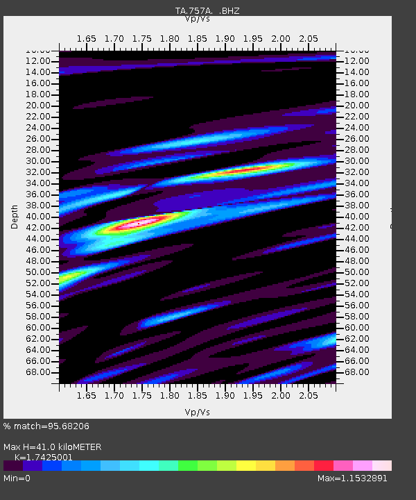
| Estimated Moho Depth: |
41.0 km |
| Estimated Crust Vp/Vs: |
1.74 |
| Assumed Crust Vp: |
5.989 km/s |
| Estimated Crust Vs: |
3.437 km/s |
| Estimated Crust Poisson's Ratio: |
0.25 |
|
| Radial Match: |
95.68206 % |
| Radial Bump: |
400 |
| Transverse Match: |
80.82105 % |
| Transverse Bump: |
400 |
| SOD ConfigId: |
446234 |
| Insert Time: |
2012-08-08 22:46:54.381 +0000 |
| GWidth: |
2.5 |
| Max Bumps: |
400 |
| Tol: |
0.001 |
|

Signal To Noise
| Channel | StoN | STA | LTA |
| TA:757A: :BHZ:20120514T10:08:37.124989Z | 20.967228 | 5.188712E-6 | 2.474677E-7 |
| TA:757A: :BHN:20120514T10:08:37.124989Z | 16.37019 | 3.107595E-6 | 1.8983256E-7 |
| TA:757A: :BHE:20120514T10:08:37.124989Z | 2.172705 | 4.4205544E-7 | 2.0345857E-7 |
| Arrivals |
| Ps | 5.4 SECOND |
| PpPs | 18 SECOND |
| PsPs/PpSs | 23 SECOND |


