You are here: Home > Network List > TA - USArray Transportable Network (new EarthScope stations) Stations List
> Station 555A McAlpin, FL, USA > Earthquake Result Viewer
555A McAlpin, FL, USA - Earthquake Result Viewer

| Earthquake location: |
Peru-Bolivia Border Region |
| Earthquake latitude/longitude: |
-17.7/-69.6 |
| Earthquake time(UTC): |
2012/05/14 (135) 10:00:40 GMT |
| Earthquake Depth: |
106 km |
| Earthquake Magnitude: |
6.4 MB, 6.2 MW, 6.2 MW |
| Earthquake Catalog/Contributor: |
WHDF/NEIC |
|
| Network: |
TA USArray Transportable Network (new EarthScope stations) |
| Station: |
555A McAlpin, FL, USA |
| Lat/Lon: |
30.12 N/82.97 W |
| Elevation: |
29 m |
|
| Distance: |
49.2 deg |
| Az: |
344.656 deg |
| Baz: |
163.072 deg |
| Ray Param: |
0.068484195 |
| Estimated Moho Depth: |
13.5 km |
| Estimated Crust Vp/Vs: |
1.60 |
| Assumed Crust Vp: |
6.565 km/s |
| Estimated Crust Vs: |
4.103 km/s |
| Estimated Crust Poisson's Ratio: |
0.18 |
|
| Radial Match: |
92.6669 % |
| Radial Bump: |
400 |
| Transverse Match: |
71.51402 % |
| Transverse Bump: |
400 |
| SOD ConfigId: |
446234 |
| Insert Time: |
2012-08-08 22:47:31.009 +0000 |
| GWidth: |
2.5 |
| Max Bumps: |
400 |
| Tol: |
0.001 |
|
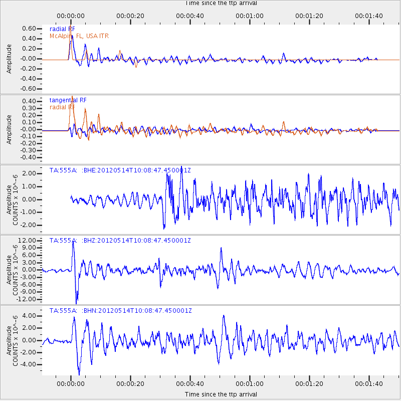
Signal To Noise
| Channel | StoN | STA | LTA |
| TA:555A: :BHZ:20120514T10:08:47.450001Z | 19.19887 | 5.9344457E-6 | 3.091039E-7 |
| TA:555A: :BHN:20120514T10:08:47.450001Z | 9.1954155 | 2.494668E-6 | 2.7129474E-7 |
| TA:555A: :BHE:20120514T10:08:47.450001Z | 4.0373707 | 1.1555204E-6 | 2.862062E-7 |
| Arrivals |
| Ps | 1.3 SECOND |
| PpPs | 5.0 SECOND |
| PsPs/PpSs | 6.3 SECOND |


