You are here: Home > Network List > TA - USArray Transportable Network (new EarthScope stations) Stations List
> Station 656A Willston, FL, USA > Earthquake Result Viewer
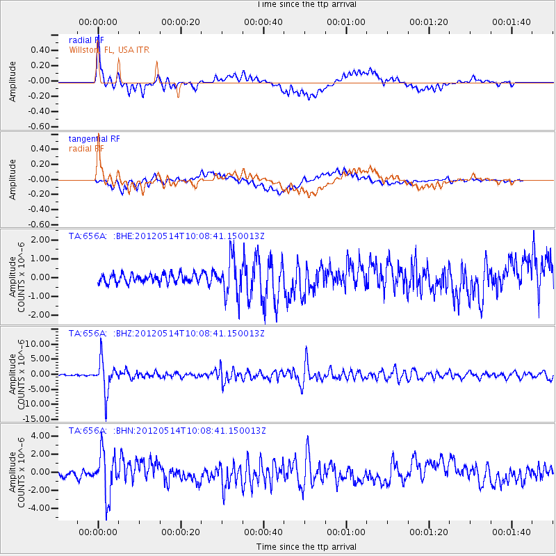
656A Willston, FL, USA - Earthquake Result Viewer
*The percent match for this event was below the threshold and hence no stack was calculated.
| Earthquake location: |
Peru-Bolivia Border Region |
| Earthquake latitude/longitude: |
-17.7/-69.6 |
| Earthquake time(UTC): |
2012/05/14 (135) 10:00:40 GMT |
| Earthquake Depth: |
106 km |
| Earthquake Magnitude: |
6.4 MB, 6.2 MW, 6.2 MW |
| Earthquake Catalog/Contributor: |
WHDF/NEIC |
|
| Network: |
TA USArray Transportable Network (new EarthScope stations) |
| Station: |
656A Willston, FL, USA |
| Lat/Lon: |
29.37 N/82.53 W |
| Elevation: |
28 m |
|
| Distance: |
48.4 deg |
| Az: |
344.846 deg |
| Baz: |
163.41 deg |
| Ray Param: |
$rayparam |
*The percent match for this event was below the threshold and hence was not used in the summary stack. |
|
| Radial Match: |
75.9095 % |
| Radial Bump: |
400 |
| Transverse Match: |
66.487175 % |
| Transverse Bump: |
400 |
| SOD ConfigId: |
446234 |
| Insert Time: |
2012-08-08 22:48:04.772 +0000 |
| GWidth: |
2.5 |
| Max Bumps: |
400 |
| Tol: |
0.001 |
|
Signal To Noise
| Channel | StoN | STA | LTA |
| TA:656A: :BHZ:20120514T10:08:41.150013Z | 26.825726 | 5.3583567E-6 | 1.9974694E-7 |
| TA:656A: :BHN:20120514T10:08:41.150013Z | 4.2696896 | 2.4595429E-6 | 5.760472E-7 |
| TA:656A: :BHE:20120514T10:08:41.150013Z | 4.4571 | 9.971233E-7 | 2.237157E-7 |
| Arrivals |
| Ps | |
| PpPs | |
| PsPs/PpSs | |


