You are here: Home > Network List > TA - USArray Transportable Network (new EarthScope stations) Stations List
> Station 957A Wimauma, FL, USA > Earthquake Result Viewer
957A Wimauma, FL, USA - Earthquake Result Viewer

| Earthquake location: |
Peru-Bolivia Border Region |
| Earthquake latitude/longitude: |
-17.7/-69.6 |
| Earthquake time(UTC): |
2012/05/14 (135) 10:00:40 GMT |
| Earthquake Depth: |
106 km |
| Earthquake Magnitude: |
6.4 MB, 6.2 MW, 6.2 MW |
| Earthquake Catalog/Contributor: |
WHDF/NEIC |
|
| Network: |
TA USArray Transportable Network (new EarthScope stations) |
| Station: |
957A Wimauma, FL, USA |
| Lat/Lon: |
27.67 N/82.24 W |
| Elevation: |
35 m |
|
| Distance: |
46.7 deg |
| Az: |
344.532 deg |
| Baz: |
163.34 deg |
| Ray Param: |
0.070099704 |
| Estimated Moho Depth: |
22.75 km |
| Estimated Crust Vp/Vs: |
1.66 |
| Assumed Crust Vp: |
5.845 km/s |
| Estimated Crust Vs: |
3.516 km/s |
| Estimated Crust Poisson's Ratio: |
0.22 |
|
| Radial Match: |
90.05916 % |
| Radial Bump: |
400 |
| Transverse Match: |
76.88766 % |
| Transverse Bump: |
400 |
| SOD ConfigId: |
446234 |
| Insert Time: |
2012-08-08 22:48:21.520 +0000 |
| GWidth: |
2.5 |
| Max Bumps: |
400 |
| Tol: |
0.001 |
|
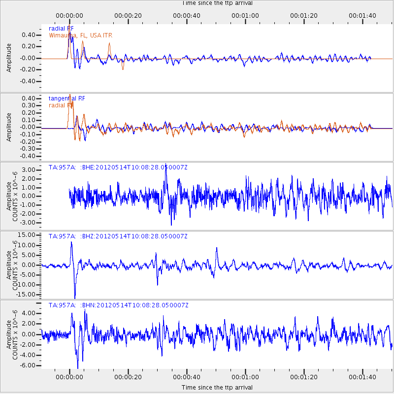
Signal To Noise
| Channel | StoN | STA | LTA |
| TA:957A: :BHZ:20120514T10:08:28.050007Z | 15.442273 | 5.713672E-6 | 3.70002E-7 |
| TA:957A: :BHN:20120514T10:08:28.050007Z | 5.225028 | 2.623806E-6 | 5.0216113E-7 |
| TA:957A: :BHE:20120514T10:08:28.050007Z | 2.4219956 | 1.3962923E-6 | 5.765049E-7 |
| Arrivals |
| Ps | 2.7 SECOND |
| PpPs | 9.8 SECOND |
| PsPs/PpSs | 13 SECOND |


