You are here: Home > Network List > G - GEOSCOPE Stations List
> Station NOUC Port Laguerre, New Caledonia > Earthquake Result Viewer
NOUC Port Laguerre, New Caledonia - Earthquake Result Viewer
| Earthquake location: |
Irian Jaya, Indonesia |
| Earthquake latitude/longitude: |
-3.2/136.0 |
| Earthquake time(UTC): |
1994/01/19 (019) 01:53:36 GMT |
| Earthquake Depth: |
33 km |
| Earthquake Magnitude: |
6.0 MB, 6.9 MS, 6.9 UNKNOWN |
| Earthquake Catalog/Contributor: |
WHDF/NEIC |
|
| Network: |
G GEOSCOPE |
| Station: |
NOUC Port Laguerre, New Caledonia |
| Lat/Lon: |
22.10 S/166.30 E |
| Elevation: |
112 m |
|
| Distance: |
34.9 deg |
| Az: |
125.126 deg |
| Baz: |
298.29 deg |
| Ray Param: |
0.07745918 |
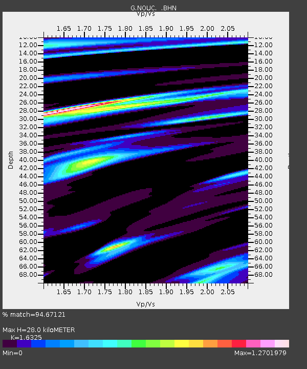
| Estimated Moho Depth: |
28.0 km |
| Estimated Crust Vp/Vs: |
1.63 |
| Assumed Crust Vp: |
5.14 km/s |
| Estimated Crust Vs: |
3.149 km/s |
| Estimated Crust Poisson's Ratio: |
0.20 |
|
| Radial Match: |
94.67121 % |
| Radial Bump: |
264 |
| Transverse Match: |
85.558426 % |
| Transverse Bump: |
400 |
| SOD ConfigId: |
4480 |
| Insert Time: |
2010-02-26 23:36:15.224 +0000 |
| GWidth: |
2.5 |
| Max Bumps: |
400 |
| Tol: |
0.001 |
|
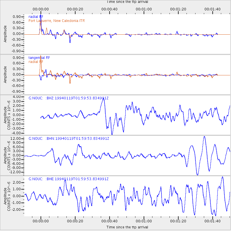
Signal To Noise
| Channel | StoN | STA | LTA |
| G:NOUC: :BHN:19940119T01:59:53.834991Z | 3.6307116 | 1.2976295E-6 | 3.5740365E-7 |
| G:NOUC: :BHE:19940119T01:59:53.834991Z | 0.9279453 | 3.587842E-7 | 3.866437E-7 |
| G:NOUC: :BHZ:19940119T01:59:53.834991Z | 1.6728528 | 6.130623E-7 | 3.6647714E-7 |
| Arrivals |
| Ps | 3.6 SECOND |
| PpPs | 14 SECOND |
| PsPs/PpSs | 17 SECOND |


