You are here: Home > Network List > TA - USArray Transportable Network (new EarthScope stations) Stations List
> Station 253A Americus, GA, USA > Earthquake Result Viewer
253A Americus, GA, USA - Earthquake Result Viewer

| Earthquake location: |
Peru-Bolivia Border Region |
| Earthquake latitude/longitude: |
-17.7/-69.6 |
| Earthquake time(UTC): |
2012/05/14 (135) 10:00:40 GMT |
| Earthquake Depth: |
106 km |
| Earthquake Magnitude: |
6.4 MB, 6.2 MW, 6.2 MW |
| Earthquake Catalog/Contributor: |
WHDF/NEIC |
|
| Network: |
TA USArray Transportable Network (new EarthScope stations) |
| Station: |
253A Americus, GA, USA |
| Lat/Lon: |
32.06 N/84.13 W |
| Elevation: |
136 m |
|
| Distance: |
51.4 deg |
| Az: |
344.169 deg |
| Baz: |
162.163 deg |
| Ray Param: |
0.067105055 |
| Estimated Moho Depth: |
15.5 km |
| Estimated Crust Vp/Vs: |
1.61 |
| Assumed Crust Vp: |
6.719 km/s |
| Estimated Crust Vs: |
4.167 km/s |
| Estimated Crust Poisson's Ratio: |
0.19 |
|
| Radial Match: |
95.38979 % |
| Radial Bump: |
394 |
| Transverse Match: |
82.442764 % |
| Transverse Bump: |
400 |
| SOD ConfigId: |
446234 |
| Insert Time: |
2012-08-08 22:48:55.698 +0000 |
| GWidth: |
2.5 |
| Max Bumps: |
400 |
| Tol: |
0.001 |
|
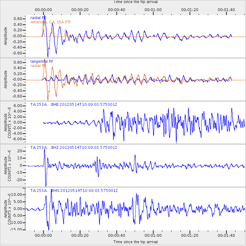
Signal To Noise
| Channel | StoN | STA | LTA |
| TA:253A: :BHZ:20120514T10:09:03.575001Z | 65.52743 | 1.0836668E-5 | 1.6537605E-7 |
| TA:253A: :BHN:20120514T10:09:03.575001Z | 23.004007 | 7.458077E-6 | 3.2420772E-7 |
| TA:253A: :BHE:20120514T10:09:03.575001Z | 5.777491 | 1.9266442E-6 | 3.3347422E-7 |
| Arrivals |
| Ps | 1.5 SECOND |
| PpPs | 5.6 SECOND |
| PsPs/PpSs | 7.1 SECOND |


