You are here: Home > Network List > TA - USArray Transportable Network (new EarthScope stations) Stations List
> Station 058A Arcadia, FL, USA > Earthquake Result Viewer
058A Arcadia, FL, USA - Earthquake Result Viewer
| Earthquake location: |
Peru-Bolivia Border Region |
| Earthquake latitude/longitude: |
-17.7/-69.6 |
| Earthquake time(UTC): |
2012/05/14 (135) 10:00:40 GMT |
| Earthquake Depth: |
106 km |
| Earthquake Magnitude: |
6.4 MB, 6.2 MW, 6.2 MW |
| Earthquake Catalog/Contributor: |
WHDF/NEIC |
|
| Network: |
TA USArray Transportable Network (new EarthScope stations) |
| Station: |
058A Arcadia, FL, USA |
| Lat/Lon: |
27.06 N/81.80 W |
| Elevation: |
15 m |
|
| Distance: |
46.0 deg |
| Az: |
344.8 deg |
| Baz: |
163.722 deg |
| Ray Param: |
0.0705539 |
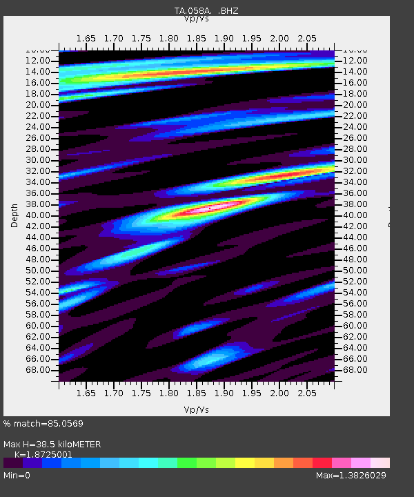
| Estimated Moho Depth: |
38.5 km |
| Estimated Crust Vp/Vs: |
1.87 |
| Assumed Crust Vp: |
6.347 km/s |
| Estimated Crust Vs: |
3.39 km/s |
| Estimated Crust Poisson's Ratio: |
0.30 |
|
| Radial Match: |
85.0569 % |
| Radial Bump: |
400 |
| Transverse Match: |
71.60333 % |
| Transverse Bump: |
400 |
| SOD ConfigId: |
446234 |
| Insert Time: |
2012-08-08 22:49:02.040 +0000 |
| GWidth: |
2.5 |
| Max Bumps: |
400 |
| Tol: |
0.001 |
|
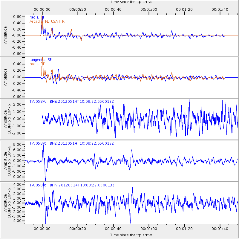
Signal To Noise
| Channel | StoN | STA | LTA |
| TA:058A: :BHZ:20120514T10:08:22.650013Z | 14.130925 | 4.519229E-6 | 3.1981128E-7 |
| TA:058A: :BHN:20120514T10:08:22.650013Z | 5.958699 | 1.8734984E-6 | 3.14414E-7 |
| TA:058A: :BHE:20120514T10:08:22.650013Z | 2.2128372 | 9.994386E-7 | 4.516548E-7 |
| Arrivals |
| Ps | 5.6 SECOND |
| PpPs | 16 SECOND |
| PsPs/PpSs | 22 SECOND |


