You are here: Home > Network List > TA - USArray Transportable Network (new EarthScope stations) Stations List
> Station 059Z Ave Maria, FL, USA > Earthquake Result Viewer
059Z Ave Maria, FL, USA - Earthquake Result Viewer

| Earthquake location: |
Peru-Bolivia Border Region |
| Earthquake latitude/longitude: |
-17.7/-69.6 |
| Earthquake time(UTC): |
2012/05/14 (135) 10:00:40 GMT |
| Earthquake Depth: |
106 km |
| Earthquake Magnitude: |
6.4 MB, 6.2 MW, 6.2 MW |
| Earthquake Catalog/Contributor: |
WHDF/NEIC |
|
| Network: |
TA USArray Transportable Network (new EarthScope stations) |
| Station: |
059Z Ave Maria, FL, USA |
| Lat/Lon: |
26.34 N/81.44 W |
| Elevation: |
8.0 m |
|
| Distance: |
45.2 deg |
| Az: |
344.956 deg |
| Baz: |
163.993 deg |
| Ray Param: |
0.07103286 |
| Estimated Moho Depth: |
21.0 km |
| Estimated Crust Vp/Vs: |
2.04 |
| Assumed Crust Vp: |
6.347 km/s |
| Estimated Crust Vs: |
3.119 km/s |
| Estimated Crust Poisson's Ratio: |
0.34 |
|
| Radial Match: |
86.52388 % |
| Radial Bump: |
400 |
| Transverse Match: |
68.94644 % |
| Transverse Bump: |
400 |
| SOD ConfigId: |
446234 |
| Insert Time: |
2012-08-08 22:49:20.868 +0000 |
| GWidth: |
2.5 |
| Max Bumps: |
400 |
| Tol: |
0.001 |
|
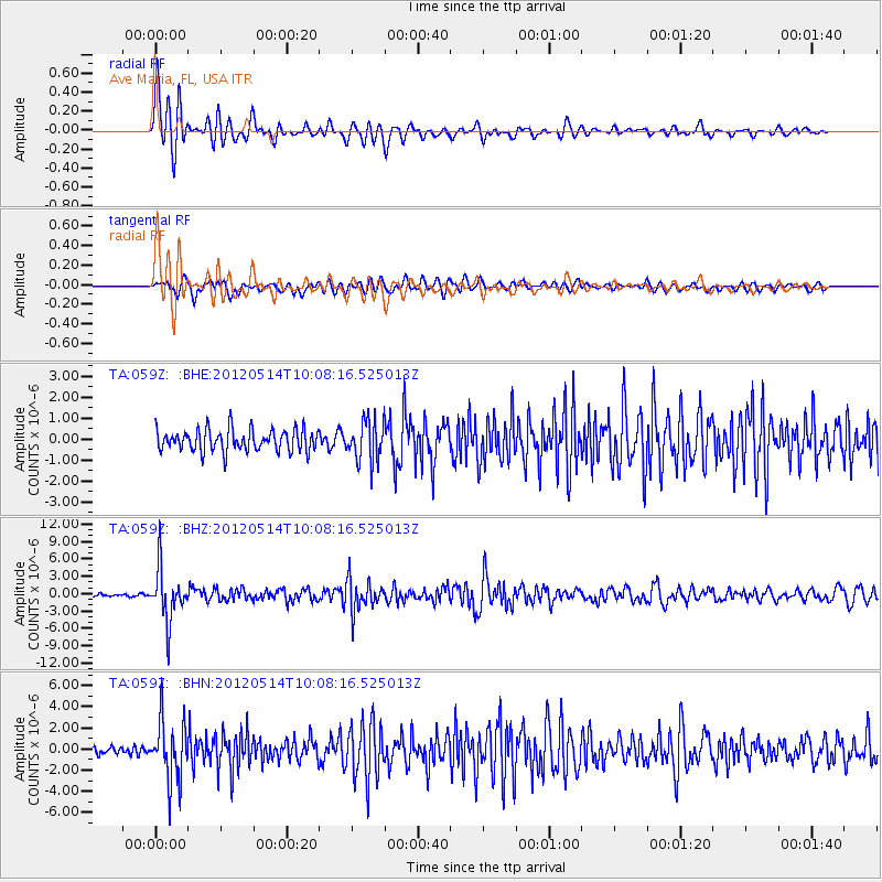
Signal To Noise
| Channel | StoN | STA | LTA |
| TA:059Z: :BHZ:20120514T10:08:16.525013Z | 14.910838 | 4.448479E-6 | 2.9833865E-7 |
| TA:059Z: :BHN:20120514T10:08:16.525013Z | 5.812206 | 2.8574432E-6 | 4.91628E-7 |
| TA:059Z: :BHE:20120514T10:08:16.525013Z | 1.8722391 | 9.779682E-7 | 5.2235214E-7 |
| Arrivals |
| Ps | 3.6 SECOND |
| PpPs | 9.5 SECOND |
| PsPs/PpSs | 13 SECOND |


