You are here: Home > Network List > TA - USArray Transportable Network (new EarthScope stations) Stations List
> Station 256A Glennville, GA, USA > Earthquake Result Viewer
256A Glennville, GA, USA - Earthquake Result Viewer
| Earthquake location: |
Peru-Bolivia Border Region |
| Earthquake latitude/longitude: |
-17.7/-69.6 |
| Earthquake time(UTC): |
2012/05/14 (135) 10:00:40 GMT |
| Earthquake Depth: |
106 km |
| Earthquake Magnitude: |
6.4 MB, 6.2 MW, 6.2 MW |
| Earthquake Catalog/Contributor: |
WHDF/NEIC |
|
| Network: |
TA USArray Transportable Network (new EarthScope stations) |
| Station: |
256A Glennville, GA, USA |
| Lat/Lon: |
31.98 N/81.89 W |
| Elevation: |
46 m |
|
| Distance: |
50.8 deg |
| Az: |
346.486 deg |
| Baz: |
164.802 deg |
| Ray Param: |
0.06750586 |
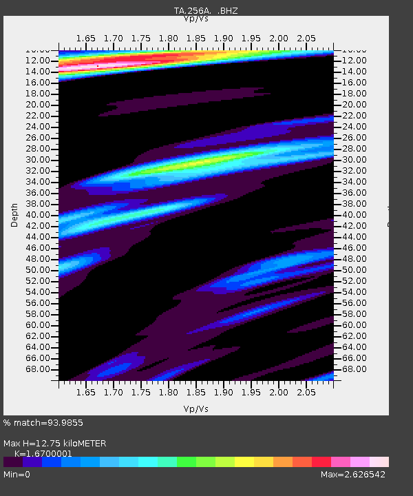
| Estimated Moho Depth: |
12.75 km |
| Estimated Crust Vp/Vs: |
1.67 |
| Assumed Crust Vp: |
5.989 km/s |
| Estimated Crust Vs: |
3.586 km/s |
| Estimated Crust Poisson's Ratio: |
0.22 |
|
| Radial Match: |
93.9855 % |
| Radial Bump: |
400 |
| Transverse Match: |
76.2896 % |
| Transverse Bump: |
400 |
| SOD ConfigId: |
446234 |
| Insert Time: |
2012-08-08 22:50:24.304 +0000 |
| GWidth: |
2.5 |
| Max Bumps: |
400 |
| Tol: |
0.001 |
|

Signal To Noise
| Channel | StoN | STA | LTA |
| TA:256A: :BHZ:20120514T10:08:58.950001Z | 21.98698 | 7.382861E-6 | 3.357833E-7 |
| TA:256A: :BHN:20120514T10:08:58.950001Z | 10.901219 | 4.155038E-6 | 3.811535E-7 |
| TA:256A: :BHE:20120514T10:08:58.950001Z | 3.1816158 | 1.8189404E-6 | 5.717033E-7 |
| Arrivals |
| Ps | 1.5 SECOND |
| PpPs | 5.4 SECOND |
| PsPs/PpSs | 6.9 SECOND |


