You are here: Home > Network List > G - GEOSCOPE Stations List
> Station NOUC Port Laguerre, New Caledonia > Earthquake Result Viewer
NOUC Port Laguerre, New Caledonia - Earthquake Result Viewer

| Earthquake location: |
Halmahera, Indonesia |
| Earthquake latitude/longitude: |
-1.2/128.0 |
| Earthquake time(UTC): |
1994/10/08 (281) 21:44:09 GMT |
| Earthquake Depth: |
31 km |
| Earthquake Magnitude: |
6.3 MB, 6.8 MS, 6.8 UNKNOWN, 6.9 MW |
| Earthquake Catalog/Contributor: |
WHDF/NEIC |
|
| Network: |
G GEOSCOPE |
| Station: |
NOUC Port Laguerre, New Caledonia |
| Lat/Lon: |
22.10 S/166.30 E |
| Elevation: |
112 m |
|
| Distance: |
42.7 deg |
| Az: |
121.952 deg |
| Baz: |
293.835 deg |
| Ray Param: |
0.072988614 |
| Estimated Moho Depth: |
61.75 km |
| Estimated Crust Vp/Vs: |
1.83 |
| Assumed Crust Vp: |
5.14 km/s |
| Estimated Crust Vs: |
2.816 km/s |
| Estimated Crust Poisson's Ratio: |
0.29 |
|
| Radial Match: |
92.16444 % |
| Radial Bump: |
299 |
| Transverse Match: |
91.67058 % |
| Transverse Bump: |
380 |
| SOD ConfigId: |
17000 |
| Insert Time: |
2010-02-26 23:36:25.865 +0000 |
| GWidth: |
2.5 |
| Max Bumps: |
400 |
| Tol: |
0.001 |
|
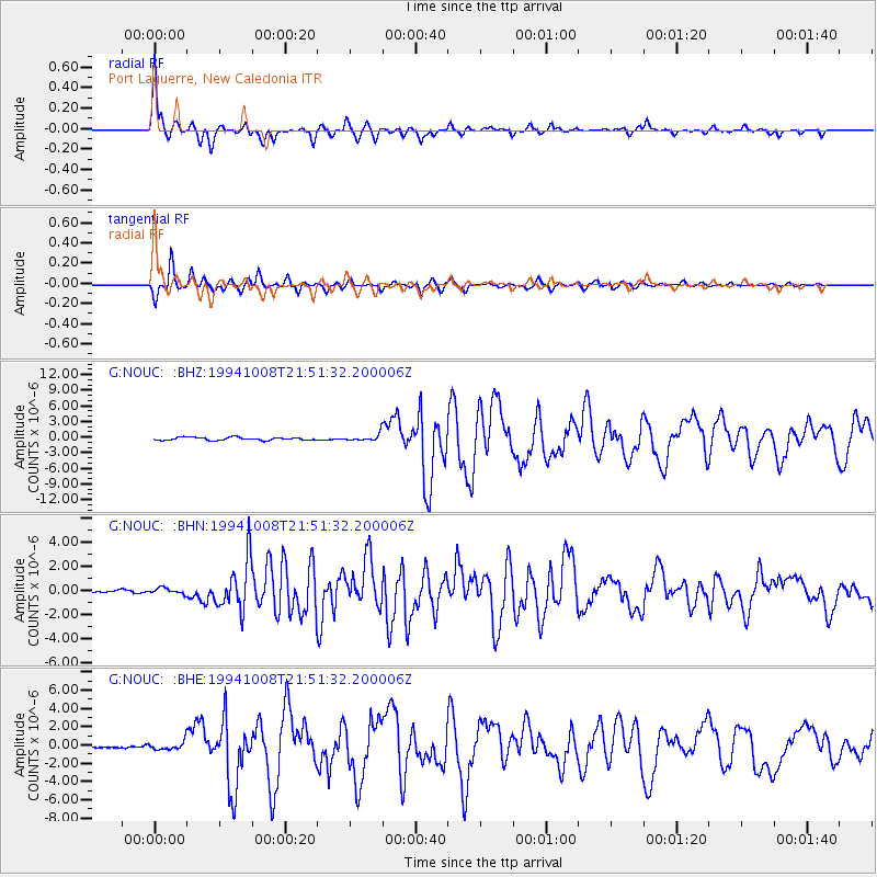
Signal To Noise
| Channel | StoN | STA | LTA |
| G:NOUC: :BHN:19941008T21:51:32.200006Z | 1.6374298 | 2.3956784E-7 | 1.4630724E-7 |
| G:NOUC: :BHE:19941008T21:51:32.200006Z | 2.9312332 | 4.4899144E-7 | 1.5317494E-7 |
| G:NOUC: :BHZ:19941008T21:51:32.200006Z | 2.3306134 | 6.610518E-7 | 2.8363854E-7 |
| Arrivals |
| Ps | 10 SECOND |
| PpPs | 33 SECOND |
| PsPs/PpSs | 43 SECOND |


