You are here: Home > Network List > TA - USArray Transportable Network (new EarthScope stations) Stations List
> Station 255A Hazlehurst, GA, USA > Earthquake Result Viewer
255A Hazlehurst, GA, USA - Earthquake Result Viewer
| Earthquake location: |
Peru-Bolivia Border Region |
| Earthquake latitude/longitude: |
-17.7/-69.6 |
| Earthquake time(UTC): |
2012/05/14 (135) 10:00:40 GMT |
| Earthquake Depth: |
106 km |
| Earthquake Magnitude: |
6.4 MB, 6.2 MW, 6.2 MW |
| Earthquake Catalog/Contributor: |
WHDF/NEIC |
|
| Network: |
TA USArray Transportable Network (new EarthScope stations) |
| Station: |
255A Hazlehurst, GA, USA |
| Lat/Lon: |
31.93 N/82.48 W |
| Elevation: |
45 m |
|
| Distance: |
50.8 deg |
| Az: |
345.846 deg |
| Baz: |
164.088 deg |
| Ray Param: |
0.06745474 |
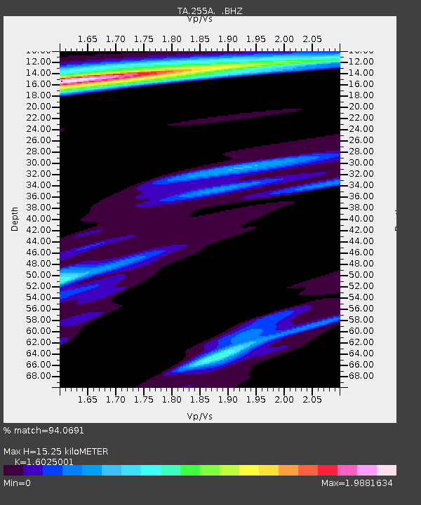
| Estimated Moho Depth: |
15.25 km |
| Estimated Crust Vp/Vs: |
1.60 |
| Assumed Crust Vp: |
6.565 km/s |
| Estimated Crust Vs: |
4.096 km/s |
| Estimated Crust Poisson's Ratio: |
0.18 |
|
| Radial Match: |
94.0691 % |
| Radial Bump: |
379 |
| Transverse Match: |
83.94843 % |
| Transverse Bump: |
400 |
| SOD ConfigId: |
446234 |
| Insert Time: |
2012-08-08 22:51:04.540 +0000 |
| GWidth: |
2.5 |
| Max Bumps: |
400 |
| Tol: |
0.001 |
|
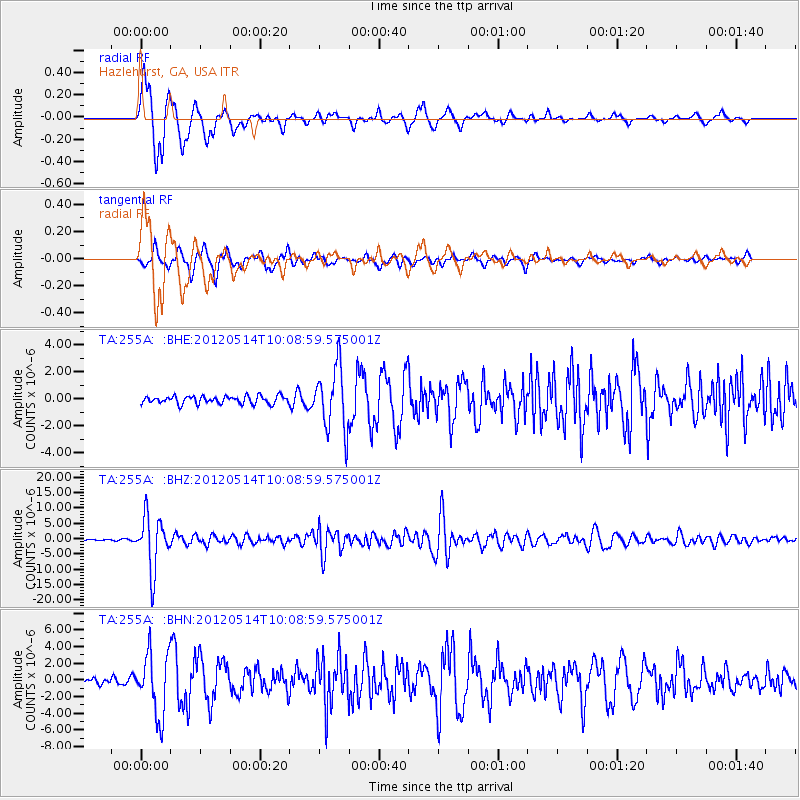
Signal To Noise
| Channel | StoN | STA | LTA |
| TA:255A: :BHZ:20120514T10:08:59.575001Z | 39.07752 | 8.708285E-6 | 2.2284644E-7 |
| TA:255A: :BHN:20120514T10:08:59.575001Z | 10.408892 | 3.7399452E-6 | 3.5930293E-7 |
| TA:255A: :BHE:20120514T10:08:59.575001Z | 8.081223 | 2.308885E-6 | 2.857099E-7 |
| Arrivals |
| Ps | 1.5 SECOND |
| PpPs | 5.7 SECOND |
| PsPs/PpSs | 7.2 SECOND |


