You are here: Home > Network List > G - GEOSCOPE Stations List
> Station NOUC Port Laguerre, New Caledonia > Earthquake Result Viewer
NOUC Port Laguerre, New Caledonia - Earthquake Result Viewer
| Earthquake location: |
Taiwan Region |
| Earthquake latitude/longitude: |
24.0/122.5 |
| Earthquake time(UTC): |
1994/05/24 (144) 04:00:46 GMT |
| Earthquake Depth: |
47 km |
| Earthquake Magnitude: |
6.0 MB, 6.6 MS, 6.3 UNKNOWN, 6.5 MW |
| Earthquake Catalog/Contributor: |
WHDF/NEIC |
|
| Network: |
G GEOSCOPE |
| Station: |
NOUC Port Laguerre, New Caledonia |
| Lat/Lon: |
22.10 S/166.30 E |
| Elevation: |
112 m |
|
| Distance: |
62.5 deg |
| Az: |
133.669 deg |
| Baz: |
314.474 deg |
| Ray Param: |
0.06007656 |
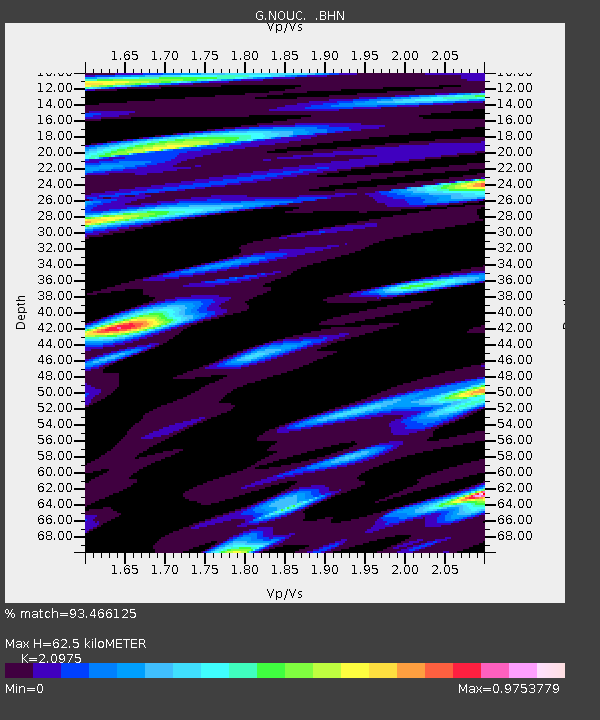
| Estimated Moho Depth: |
62.5 km |
| Estimated Crust Vp/Vs: |
2.10 |
| Assumed Crust Vp: |
5.14 km/s |
| Estimated Crust Vs: |
2.451 km/s |
| Estimated Crust Poisson's Ratio: |
0.35 |
|
| Radial Match: |
93.466125 % |
| Radial Bump: |
320 |
| Transverse Match: |
88.875656 % |
| Transverse Bump: |
400 |
| SOD ConfigId: |
4480 |
| Insert Time: |
2010-02-26 23:36:30.550 +0000 |
| GWidth: |
2.5 |
| Max Bumps: |
400 |
| Tol: |
0.001 |
|

Signal To Noise
| Channel | StoN | STA | LTA |
| G:NOUC: :BHN:19940524T04:10:34.349011Z | 6.4756727 | 1.251084E-6 | 1.9319754E-7 |
| G:NOUC: :BHE:19940524T04:10:34.349011Z | 1.2879457 | 2.5984883E-7 | 2.0175449E-7 |
| G:NOUC: :BHZ:19940524T04:10:34.349011Z | 3.0530589 | 5.3050155E-7 | 1.7376067E-7 |
| Arrivals |
| Ps | 14 SECOND |
| PpPs | 37 SECOND |
| PsPs/PpSs | 50 SECOND |


