You are here: Home > Network List > G - GEOSCOPE Stations List
> Station NOUC Port Laguerre, New Caledonia > Earthquake Result Viewer
NOUC Port Laguerre, New Caledonia - Earthquake Result Viewer
| Earthquake location: |
Samar, Philippines |
| Earthquake latitude/longitude: |
12.0/125.7 |
| Earthquake time(UTC): |
1995/04/21 (111) 00:09:56 GMT |
| Earthquake Depth: |
33 km |
| Earthquake Magnitude: |
6.1 MB, 6.9 MS, 6.9 UNKNOWN, 6.8 MW |
| Earthquake Catalog/Contributor: |
WHDF/NEIC |
|
| Network: |
G GEOSCOPE |
| Station: |
NOUC Port Laguerre, New Caledonia |
| Lat/Lon: |
22.10 S/166.30 E |
| Elevation: |
112 m |
|
| Distance: |
52.3 deg |
| Az: |
130.277 deg |
| Baz: |
306.398 deg |
| Ray Param: |
0.06679275 |
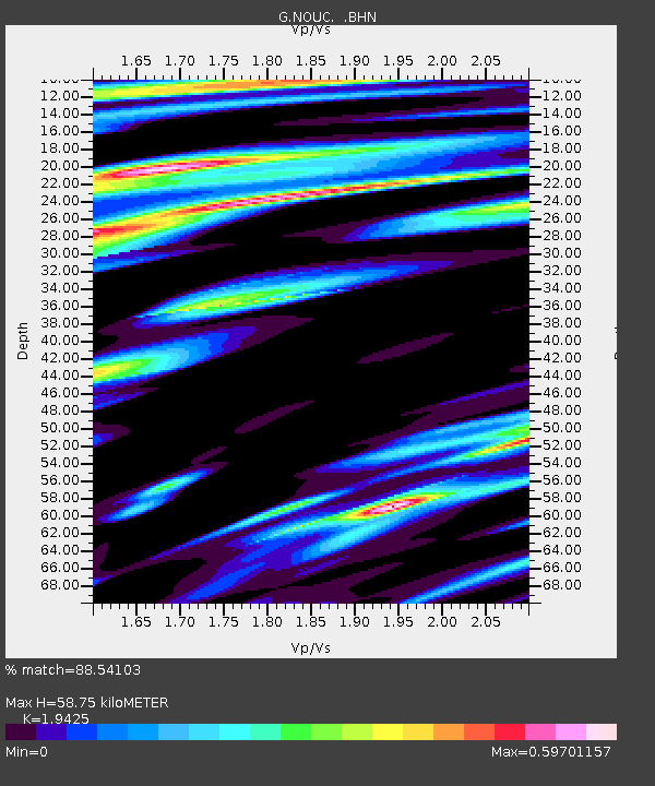
| Estimated Moho Depth: |
58.75 km |
| Estimated Crust Vp/Vs: |
1.94 |
| Assumed Crust Vp: |
5.14 km/s |
| Estimated Crust Vs: |
2.646 km/s |
| Estimated Crust Poisson's Ratio: |
0.32 |
|
| Radial Match: |
88.54103 % |
| Radial Bump: |
360 |
| Transverse Match: |
84.466064 % |
| Transverse Bump: |
400 |
| SOD ConfigId: |
6273 |
| Insert Time: |
2010-02-26 23:36:32.613 +0000 |
| GWidth: |
2.5 |
| Max Bumps: |
400 |
| Tol: |
0.001 |
|
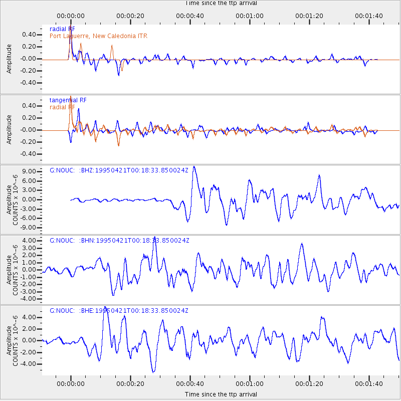
Signal To Noise
| Channel | StoN | STA | LTA |
| G:NOUC: :BHN:19950421T00:18:33.850024Z | 1.1715771 | 4.9823876E-7 | 4.2527185E-7 |
| G:NOUC: :BHE:19950421T00:18:33.850024Z | 1.0445235 | 3.6547436E-7 | 3.498958E-7 |
| G:NOUC: :BHZ:19950421T00:18:33.850024Z | 2.8523655 | 8.4960254E-7 | 2.9785892E-7 |
| Arrivals |
| Ps | 11 SECOND |
| PpPs | 33 SECOND |
| PsPs/PpSs | 44 SECOND |


